

It’s been a bumpy start to the water year. Just over three inches of precipitation fell at the Reno Airport towards the end of October, making it the wettest October on record. For some, this may have given the impression that we were off to a strong storm season. Then November proved otherwise, with warm temperatures and plenty of sunshine.
December was very active with more than one significant storm rolling through the Sierra. After feet of snow fell in the Sierra, January 2022 has turned out to be very quiet and dry. Our drought situation has improved but still has a ways to go.
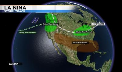
So why is this happening? There is a huge area of high pressure in the ocean, and even a little wiggle in the jet stream can allow for more moisture or even an atmospheric river to move in here. A few atmospheric rivers can give us a years worth of rain and snow. The one that moved through in October was quite significant. This has been a fairly typical La Nina year. Keeping the storm track to the north. While we have seen moments of heavy precipitation, the Pacific Northwest continues to get hit with storms on a more regular basis. If we’re lucky, the storm track can move a little farther south and give us a chance for snow. The jet stream circles around the globe, and the more ridges and troughs there are the stormier the pattern.
While January is typically our wettest month in Reno, there was a prolonged dry period in 2011 after a good start to the season, as well as in 2013. While the lack of snow in January is not the best news for our water supply, it is also not unheard of.