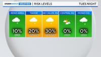
It’s been just over a couple weeks since the Sierra saw any snow. While nothing huge is lined up this week, there is a chance for some light snowfall in the Sierra late Tuesday into early Wednesday morning. This won’t be a big enough storm to really boost our snowpack, but it could still cause some slick spots along I-80 and in Lassen County.

Similar to a trough, but found in the upper levels, is a shortwave. A true pressure trough is found with either a cold or warm front in the lower levels, and is bigger in size. A shortwave is a front found in the upper levels of the atmosphere and can be cooler than its surroundings. This is like a kink in a piece of rope. Most shortwaves are about the same size of two states put together. They are usually found in the 500 or 700mb level of the atmosphere.

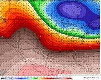
When there is enough moisture, shortwaves can still cause a decent amount of rain or snow to fall. However, moisture will be lacking Tuesday night, with an unfavorable wind direction to get much spillover in the valley. The band of rain and snow will fall apart as it moves east. This will be a fast system too. Larger storms can stick around much longer. A few flurries are possible in Reno Wednesday morning, but chances are very low.

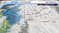

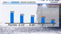
Donner has an 80% chance of seeing flurries, a 60% chance of seeing a dusting, and a 40% chance of getting an inch. The last time the Central Sierra Snow Lab saw any snow was on January 8th. That is the same day Reno picked up an 1.5” of snow at the airport.

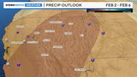
The extended forecast is trending warmer and drier than average through the first week of February.