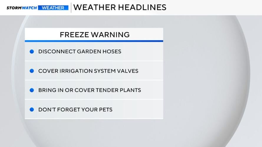
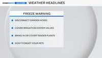


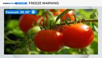

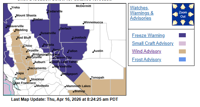


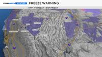
Freeze Warnings are up for the Truckee Meadows on Friday morning, so make sure to protect any sensitive vegetation. A Freeze Warning is in effect from 11 p.m. Thursday until 8 a.m. Friday for the Greater Reno-Carson-Minden area, Northeast California, the Surprise Valley, North Washoe County, South Lyon County, Mineral County, and western Nevada Basin and Range. This will be a hard freeze, meaning lows will dip below 29 degrees and remain below freezing for at least an hour. Sub-freezing temperatures are expected with lows ranging from 20 to 30 degrees on Friday morning.

Thursday will be cold too, with highs in the low 50's and wind chills in the 40's. Without any protection, most seasonal vegetation will not survive. Protect pipes, plants, and your pets.
The Freeze Warning includes Reno, Carson City, Minden, Northeast California, Fallon, Fernley, and Lovelock. Freeze this time of year is not unheard of, but after a warm March, many flowers and vegetation have already bloomed. You'll want to protect any outdoor plants on Friday morning as a result.

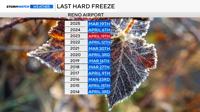
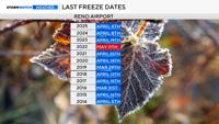
Reno usually sees its last hard freeze on April 8th, but a couple of years ago, it happened on April 19th. This is only the middle of April, so while we will drop below freezing on Friday morning, more active weather is in the forecast next week, too.
We’ve been colder. The record low at the Reno Airport on April 17th is 14 degrees, set back in 1947. Thirteen degrees is the coldest low temperature on record for the entire month. Reno usually sees its last freeze on April 26th. A few years ago, Reno even fell below freezing in May!

The warmest spot will be the airport on Friday morning, with a low of 27 degrees. This means that Cold Springs will be in the lower 20's, and many of our neighborhoods will be around 23 or 24 degrees Friday morning. Carson City will reach a low of 21, and South Tahoe will be in the mid-teens. Lows will be several degrees warmer on Saturday, with highs just above 70 degrees.

The odds of a hard freeze occurring are strong. The ingredients are there for a cold start. Skies will be clear, winds will be light, and a cold air mass will be in place. Dry air cools off quickly. This is called radiational cooling and happens frequently in a desert location.
There is a 90% chance of reaching freezing on Friday morning in Reno, a 70 percent chance of falling below 30 degrees, and a 60% chance of reaching 28 degrees at the Reno Airport. Odds are even greater when you get outside of downtown or the airport. Fallon will reach 23 degrees on Friday morning as well.


Besides a freezing start, Friday will be a nice day. Winds will be light and skies will be partly cloudy. Highs will be in the mid to upper 50’s.
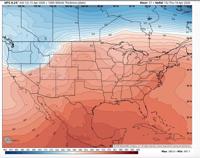
Thursday will be a cold day too. A cold front will move through the region late Wednesday, and in its wake, a cold air mass and deep trough will sit over Nevada on Thursday. The jet stream separates cold air to the north and warm air to the south. Northern Nevada will be north of the jet stream on Thursday, allowing cold air to pull in from the north. It will also be breezy on Thursday, making it feel even colder.
Keep your winter coats handy, you'll need them on Thursday and Friday. More unsettled weather is in the forecast next week as well.