


If you are heading for the mountains this Presidents' Day weekend, you may want to keep a close eye on the forecast.
A powerful winter system is expected to move in Sunday evening and strengthen through Thursday, bringing what forecasters say could become one of the most impactful storms of the season for the Sierra and Lake Tahoe.
The timing falls over the Presidents' Day holiday, when many people typically travel to the mountains.
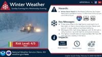
The National Weather Service in Reno said conditions will remain cool and calm to start the weekend, with heavy Sierra snow expected by Monday before the end of the holiday weekend.
A Winter Storm Watch remains in effect from Sunday evening through Wednesday evening for the Greater Lake Tahoe Area, Mono County, and parts of northeast California.
Chief Meteorologist Chris Larson said this storm could be a long-duration event unfolding over several days, and that a Winter Storm Watch could be issued as early as Friday morning or afternoon.
In the Greater Lake Tahoe Area, including Tahoe City, Homewood, South Lake Tahoe, Carnelian Bay, Hope Valley, and Markleeville, snow accumulations between 18 and 30 inches are possible in the basin, with 2 to 5 feet along the Sierra crest.
Winds could gust 35 to 45 mph in valleys, with Sierra ridge gusts over 100 mph. The highest snowfall rates are expected late Monday afternoon through Tuesday afternoon.
In Mono County, heavy snow is forecast from Sunday evening through Wednesday evening. Areas west of Highway 395, including Conway Summit, Lee Vining, June Lake, Mammoth Lakes, and Toms Place, could see 15 to 30 inches, with 2 to 4 feet in the high Sierra.
Communities near and east of Highway 395, such as Bridgeport, Walker, Bodie, and Benton, could receive 8 to 18 inches, while the Chalfant Valley may see 2 to 4 inches.
Winds are expected to gust 35 to 45 mph, with wind-prone areas along US 395 seeing gusts up to 65 mph and Sierra ridge gusts over 100 mph. Forecasters say conditions will rapidly deteriorate Monday evening, with the heaviest snowfall rates anticipated Monday night through Tuesday evening.
In Lassen, eastern Plumas, and eastern Sierra counties, 6 to 12 inches of snow are forecast west of Highway 395, with up to 2 feet at higher elevations west of Highway 89, including Plumas Eureka, Graeagle, Portola, and Lake Davis. Valley locations along and east of Highway 395, including Susanville, Janesville, Standish, and Doyle, could see 2 to 6 inches.
Winds could gust 35 to 45 mph, with up to 65 mph in wind-prone areas along US 395. Elevations below 5000 feet are expected to start as rain, changing to snow Monday afternoon into evening.
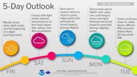
Forecasters say impact days are expected Monday, Tuesday, and Wednesday as the system moves through the region. Travel could be very difficult to impossible at times, with periods of whiteout conditions and potential damage to trees and power lines from strong winds.
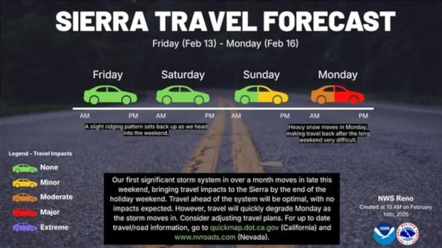
Anyone planning travel into the Sierra over the holiday weekend is encouraged to monitor the forecast closely as conditions develop. For the latest weather updates, download the free Storm Watch Weather App or visit 2news.com/weather. For current road conditions, drivers can check NVroads.com in Nevada and QuickMap.dot.ca.gov in California.