It’s been a great start to our snow season with a few good storms rolling through the region already. Our latest storm brought heavy rain and snow, as well as strong winds along with it. The storm was fueled by an atmospheric river and dynamic area of low pressure moving in from the west. Once the atmospheric moved south of Tahoe, cold air ushered in behind it and switched the rain over to snow in the valley.

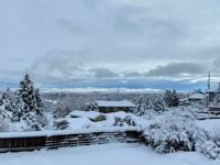
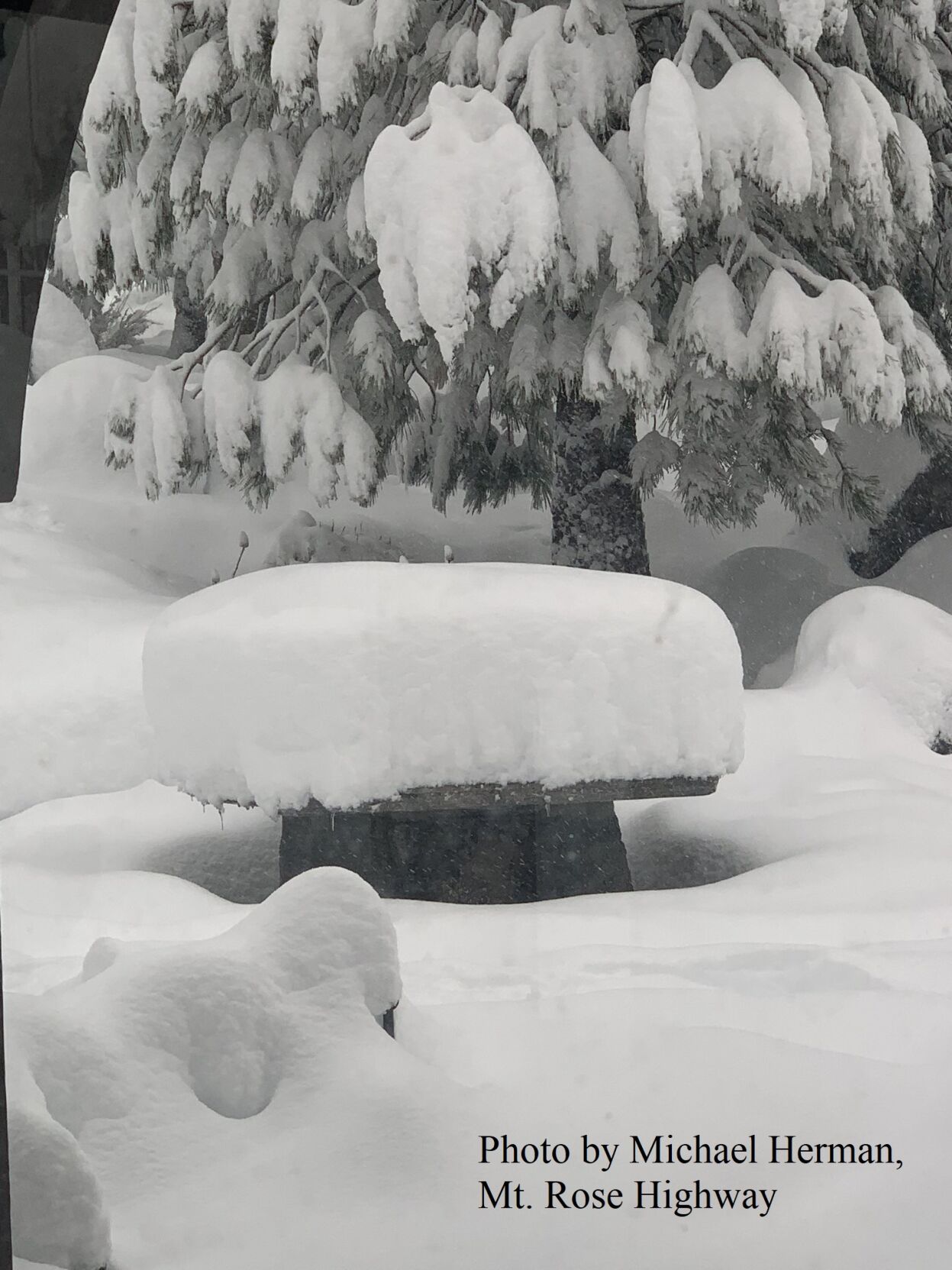
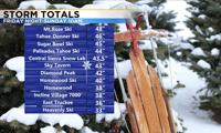
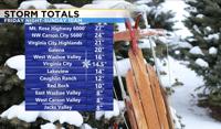
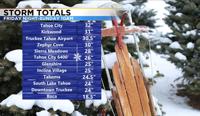
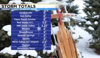
Snow totals ranged from a couple inches in downtown Reno to several feet of snow in the Sierra. Lake Tahoe got anywhere from two to three feet. Winds were strong Saturday morning before the rain arrived. According to one report in Sparks it was strong enough to knock over a fence. The Reno airport even clocked a wind gust over 60mph during the 6am hour on Saturday.
Travel will be better later Monday over the pass, but not perfect because of the leftovers. As of 10am Monday morning, chain controls are still up for our mountain passes including I-80 at Donner. Mt. Rose Highway is also closed from mile marker 10 upward.
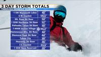
The following snow totals goes through Sunday morning.

A brief, light, snow shower can’t be ruled out in the Sierra on Monday, but most of the snow will stay east of Reno as the low moves east as well. A weak shortwave is also moving by to the north of I-80 bringing light snow to Winnemucca and Elko.
Temperatures this week will be in the mid to upper 30’s with lows in the teens. Roads will be better Tuesday morning, but the snow will likely stay on our yards for a while. Freezing fog is possible in the Sierra the next several mornings, but it will be patchy with clouds developing as well.

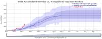
According to the National Weather Service in Reno, this is a great start to our snowpack. Let’s hope this carries over into January and February. Last December was a great month as well, but then we dried out in January and February. Fingers crossed that does not happen again. The Weather Service says we are ahead of the game, with our snowpack already sitting where it should be on January 9th-10th. We’ve already received 38-40% of our average annual snowpack.

The Central Sierra Snow Lab at Donner Pass is at 299% of normal, which is fantastic news and quite impressive. They’ve already received 153.7 inches of snow since the water year began October 1st. Reno also got over eight tenths of an inch of rain out of the storm on Saturday.

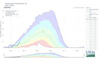
Snow ratios were low on Saturday, meaning the snow had a lot of water content. Colder, drier, snow is fluffy but lacking in moisture. While colder snow accumulates and piles up better, wetter/warmer snow is great for our snowpack. This is typically called Sierra Cement around here.

Usually you can take the amount of liquid and multiple it by 10 to get the snow total in inches, but the ratio was closer to 8:1 this time around on Saturday because of warmer air coming up from the Pacific.

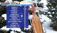
An atmospheric river is a plume of moisture coming up from the Hawaiian Islands. Atmospheric rivers provides us with a good percentage of our water supply each year. In general, the hills got between 5 and 12 inches of snow this weekend.

The rest of the week will be partly cloudy with highs in the 30’s and lows in the teens and single digits. Stay warm.