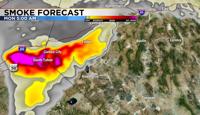
After a brief break from the thick smoke, more smoke has moved into the Truckee Meadows and is expected to stick around throughout much of Monday.
The air quality will likely get worse as well, reaching unhealthy levels throughout the Reno area.
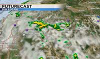
Not much has changed with the forecast, still expecting a round of showers and thunderstorms on Monday. The rain will help to flush out the smoke, but gusty outflow winds could go either way.
Sometimes they help to clear out the smoke and sometimes they can make it worse. Most of the storms will stay south of I-80 Sunday evening.
A Flood Watch has been posted for central and eastern Nevada beginning late Tuesday morning and going through Wednesday night. The air quality in Reno is expected to reach Unhealthy for Sensitive Groups on Monday and moderate levels on Tuesday.
Places like Carson City and areas south of I-80 will see more smoke than areas to the north.
Lake Tahoe will stay smoky over the next couple days, with some improvement if it rains. The rest of the blog is posted below, not much has changed.
***Original Blog***
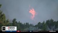
Wind direction is key with how much smoke moves in here. The Mosquito Fire is the main culprit of the smoke and is located to the west of Lake Tahoe.
Our winds came out of the east for part of Saturday, but then started coming out of the west towards the evening, allowing more smoke to move in here. Wind speeds are also just strong enough to move the smoke into the Truckee Meadows, but not strong enough to break it a part.
The air quality in Reno is very unhealthy as of 9pm Saturday, with not a ton of improvement expected on Sunday. The only thing that could help our air quality Sunday afternoon is a chance for rain.

The remnants of what was Hurricane Kay earlier this week is now moving north, bringing moisture into southern Nevada. The moisture expands northward reaching the Truckee Meadows by Sunday afternoon.
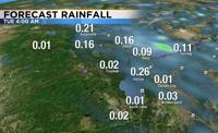
Rain totals will vary greatly, ranging from a few hundredths of an inch, to upwards of a quarter of an inch. Thunderstorms are scattered, which means not everyone will get wet.

Gusty outflow winds can sometimes improve our air quality but can also make things worse. Outflow winds rush out of the storm in a variety of directions, which is why they can both hinder or improve our air quality. Some steady rain would be ideal.
There is a slight chance it could rain over the Mosquito Fire this weekend, but it’s only about a twenty percent chance on Sunday and a thirty percent chance on Monday. Along with lightning, the storms could also produce gusty winds and pockets of heavy rain.
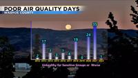
Fingers crossed we don’t’ get any more fire starts, but it will be challenging to line the lightning up exactly with the rain cores. I’m thankful we had a summer filled with clean air. In fact, as of a few weeks ago, Washoe County only had one day with poor air quality. Poor air quality meaning worse than moderate.

The strong ridge that brought us so much heat this month is finally moving to the east, changing the wind flow and allowing for some moisture to move in. Many records were broken in Reno, not only during the day but also at night.
Seven records were broken during the day in September, and we also tied a couple records at the end of August. September 6th 2022 is now the hottest day on record in Reno for the entire month. This is also the 4th hottest temperature ever recorded in Reno.

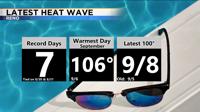
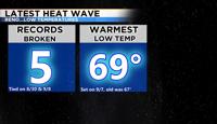
Last year we broke the record for most 100 degree days throughout the entire year, but because of our latest heat wave, we wound up tying it this year. It was warm at night too. Reno broke five daily low temperature records and tied two.
September 7th also had the warmest start to the day ever recorded during the month of September. The low was 69 degrees. While it is smoky outside, at least it will be cooler this week and there is also a chance for rain.