Fire danger will be critical on Thursday in the Truckee Meadows with wind gusts near 40mph and low relative humidity values. Another strong area of low pressure will slip into the Pacific Northwest on Thursday, hugging the coastline. The low will tighten the pressure gradient, with moisture taking a while to move into the area. Relative humidity values will be below 20% on Thursday before clouds form on Friday.

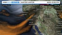
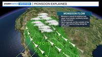
While a low is moving towards the Pacific Northwest, a high is centered over Colorado, with monsoonal moisture wrapping around it. While monsoonal moisture can move into the Truckee Meadows, it's usually along the outside of it. A slight wobble in the high from west to east alters our forecast drastically this time of year. Most of our storms forms right along the jet stream itself. Thunderstorms tends to fire along boundaries, such as dry air next to moist air. Temperature boundaries causes the air to rise as well.

As a deep area of low pressure moves in from the north, the ridge and monsoonal moisture will move to the east. The monsoon season begins in June and goes through September. 2023 was an impressive year for the southwest monsoon, but this year, multiple cities, including Las Vegas are seeing a dry summer season.

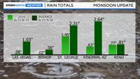
When you look at the data alone, one would think Reno is having a fairly typical summer season in terms of precipitation, but most of it fell in one day. Reno usually sees just over eight tenths of an inch of rain during the monsoon season, we've received just below that already. St. George, Utah is roughly an inch behind, and Kingman, Arizona is basically two inches behind. Kingman, Arizona usually sees about three inches and a quarter between the middle of June and the end of September.

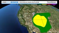
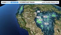
There is a slight chance of excessive rainfall over the Four Corners Thursday, as the monsoon will be right overhead. Dry air will be coming out of the southwest in the Reno area on Thursday with critical fire danger. The dry air will undercut the low to our north.