Round two of the winter weather moves through the region on Tuesday, bringing more snow, wind, and rain.
An area of low pressure will move through northern California and Nevada throughout the day, keeping us unsettled and cold. It will take a while before temperatures reach normal again. There won’t be as much moisture to work with this time, but there will be plenty of forcing thanks to the low moving in.
The snow level will stay below 6000’ today, allowing for only snow to fall at lake level. Both rain and snow will fall in the Truckee Meadows, melting as it hits the ground below 5000’ and before dark.

The snow will be pretty steady in the Sierra but more scattered in the valley. Snow will fall in the Sierra Tuesday morning because of orographic lift and westerly flow in advance of the low; the snow that falls later will be because of the low moving overtop of us.
As the cold low moves in, the air will be more conducive for thunder and lightning as well.
Daytime heating will also help to fuel more scattered snow showers, both in the Sierra and the valley.
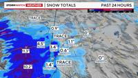
Storm snow totals will range from 1-4 feet at the crest to 6-15” at lake level and 1-4 inches in the foothills. Snow totals will double what fell on Monday.
Radar shows almost a foot of snow already falling in the high Sierra on Monday; Tuesday will produce about the same. Several inches fell at the Central Sierra Snow Lab on Sunday too.

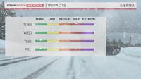
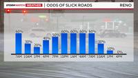
Travel impacts are high today in the Sierra and medium in the Truckee Meadows, mainly above 5000’.
Most of Wednesday will be dry, except for a stray shower developing. It will also be icy in the valley on Wednesday morning because of frozen puddles. Like Tuesday, the ice will be patchy and worse in the foothills, as well as over bridges and overpasses.
Highs on Tuesday will be in the mid-40s with gusty winds. The cold upper low will finally be out of here by Thursday, allowing for a gradual warming and drying trend. Highs on Wednesday will be in the 40s.