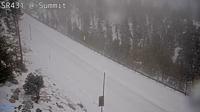
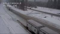
Chain controls are up for many of our mountain passes Thursday morning, including Mt. Rose Highway and I-80 at Donner because of snow and slick roads.
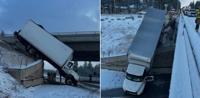
Truckee Fire Protection District posted two photos of a semi-truck that went over the edge of a bridge along I-80. Thankfully, the driver was not hurt.

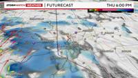
A cold front will move through by late morning, followed by an upper level low later this afternoon. Most of the snow will be done by 11am, but a second round could develop later this afternoon, all be it light and spotty.
The Winter Weather Advisory for the Tahoe Basin goes through 4pm Thursday. Snow fall rates could reach a couple inches per hour Thursday morning as the front gets closer.

There is more wind than anything else in the valley Thursday morning, with gusts over 40mph at times. This is because of a good rain shadow effect, keeping the snow mainly on the western side of the Sierra. Temperatures are also ten degrees above freezing in the Reno area, lowering the threat of snow and slick roads. The low is showing signs of stretching, becoming more southerly, cutting off the chance for spill over. However, some snow is spilling over along Mt. Rose Highway, but is having a harder time reaching the Truckee Meadows.
There is a chance a few spotty showers could develop in the Reno, Carson City area through later this evening. Rain totals will be less than a tenth of an inch. More than likely, roads will be fine in the Reno area for the evening commute, but we’ll have to watch it carefully. Temperatures will tank overnight as the low leaves.

Another storm will move through the region late Friday into Saturday. Possibly carrying over into early Sunday morning. Sunday itself will be much quieter, but cold.