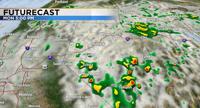
After a prolonged period of hot weather some cooler air will move in on Monday. As the weather pattern changes more moisture will move into northern Nevada as well. Highs on Sunday will be in the upper 90’s with mostly cloudy skies and a thirty percent chance for rain and thunderstorms. The first half of the day will be dry in Reno, but the later half will pose a threat of storms. Most of the activity and the bulk of the rain will fall south of Highway 50 the next few days, but more moisture will move north over the next 48 hours. The ridge that brought as all of the heat this past week is finally moving east allowing for the wind flow and jet stream to change direction. The storms will follow the path of the jet stream and come up from the south on Sunday.

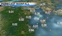
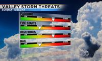
Without a strong steering current, the storms will move at a fairly slow pace, allowing the storms to produce more rain over the same locations. This is good news in terms of fire danger, but could also produce flash flooding over recent burn scars and ponding on roadways. Standing water is oftentimes deeper than what it appears, so make sure to turn around instead of drive through it. Strong thunderstorms that are heavy rain producers can produce over an inch of rain within its lifetime. Rain totals will range from a few hundredths of an inch to over a quarter. Thunderstorms are tricky because they are scattered and not widespread. It can be sunny and dry where you live, but drive five minutes down the road and it’s pouring. Precipitable water values will be quite high for our region with this event. This is a good indication that the rain will be able to combat the lightning and fire danger. Precipitable water is the amount of moisture above a certain location, or how much moisture is in the air. For example, if you have a precipitable water value of one inch, it does not tell us it will rain an inch, but rather means if all the moisture in the air at a certain point were condensed it would be an inch. Our precipitable water values will be high for our area through Tuesday.


Fire danger will be elevated because of the storms, but not as high as it could be because of the rain. The hard part is getting the rain lined up exactly with the rain itself, especially as the storm dies and collapses. Gusty winds and hail are also possible with any storms that do develop this week. The storms on Tuesday will be stronger and could reach severe limits.

All of the rain is a result of our monsoon season. A monsoon is a seasonal reversal of winds, mainly at the surface. The flow around high pressure is clockwise, so when the high is centered just to our east over the four corners, we can pick up on the southerly flow bringing up more moisture. An area of low pressure to our northwest can impact the location of the monsoon and move it farther to the east. A southwest versus a southerly wind can mean a dry versus stormy day. Areas closer to the ocean will see the most rain. The amount of cloud cover in the morning, can also limit the amount of thunderstorm activity that occurs. This is possible when moisture levels are high enough, and could happen on Monday. You can also follow me on my Facebook page KTVN Angela Schilling for more weather updates. Have a good day!