
2017 has been a tough year for some northern Nevada residents. Flooding has affected areas from the California state line to Elko County. Data shows that even more flooding could be on the way once more snowmelt makes its way down streams and rivers.
"This isn't a one-day event," Governor Brian Sandoval said. "There's going to be this sustained run-off that is going to gradually creep and increase the amount of water that's coming out to the effected areas."
This year's snowpack is more than double the amount of an average year. Experts say an average of four to six feet of water content is in the snow, and even more than that in some areas. The water is coming. The question is how fast the snow melts.
"It's difficult to imagine what this would look like when you start talking about the values of water that are up there, and flooding for an extended period," Col. Cory Schulz, Nevada National Guard Director of Joint Operations said.
Data shows the Carson Basin has enough water content to fill the Empire State Building 866 times. The Walker Basin would fill it 753 times. The combined volume of water is 447 billion gallons.
"To know what's coming and to know how to be better-prepared for what's coming is absolutely critical," Caleb Cage, Chief of Division of Emergency Management for the Nevada Department of Public Safety said.
That's why water is being released from Lahontan Reservoir, into the desert around Fallon. The goal is to make more room for the spring run-off. Nobody can predict how fast the snow will melt. The worst-case scenario would be a warm rain storm, causing the snow to melt quickly. Officials are hoping for a long, sustained snowmelt.
"Our biggest wish is that there's still snow up there in the fall when it starts snowing again, but we don't know," Schulz said.
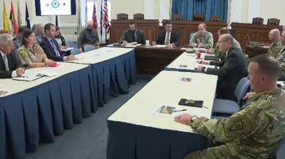
Sandoval met with members of several state agencies to discuss everything from flood mitigation efforts to infrastructure. The state has already spent millions of dollars to repair major highways, and to install culverts to prevent flooding.
"We're very fortunate and blessed that we have experienced people that are prepared to handle this," Sandoval said. "We're not going to be caught off-guard. We're going to be prepared for this and we're going to plan as much as we can and we will take every obstacle as they come."
Sandoval says the plan is a "bottom-up" approach, starting with local governments. Lyon, Churchill, and Douglas Counties have already declared emergencies, in anticipation of spring flooding, which asks for state resources. From there, Sandoval can declare an emergency for federal relief. The governor has already done that twice, which the Trump administration has approved within days.
"In my experience as governor, in the past six years, I've never seen this much cooperation between all the state agencies, the local government and federal government, and frankly, that's our job," Sandoval said.
The weather will do what it wants and the snow will melt at its own pace, but the good news is there is time to plan ahead. Sandoval says it is critical to let the public know that planning is underway, but also to let them know that they can prepare, too.
"For those that are in those effected areas, that they can get those sandbags or get those vapor barriers or get what they need in order to protect their homes," Sandoval said.
Along with spring run-off, officials are concerned about possible flash floods, and wildfire. Agencies like the Department of Forestry could be balancing resources and personnel for flooding, just as fire season gets underway.
