Thunderstorms can be very dangerous, producing heavy rain, lightning, hail, and strong winds. Outflow winds in particular can be dangerous around here and happen more often when the air is dry opposed to when we have a lot of moisture. Outflow winds are a cool rush of air accelerating down from a thunderstorm. When the air hits the ground the air spreads out in a variety of directions, very similar to a water balloon crashing to the ground.
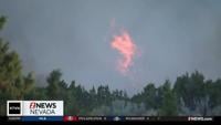
Erratic winds can be dangerous for a variety of reasons, the first being the spread of fires. Red Flag warnings are issued in Reno when wind gusts are over 35 miles per hour and outflow winds can be twice as fast if not more. The faster the wind, the easier a fire spreads.
The direction of spread is the next danger. Erratic outflow winds can change the direction of a fire quickly, which is dangerous for firefighters and anyone else close to the flames. Along with fires comes smoke, which can be carried downwind hundreds of miles. This happened Tuesday night in Reno with storms moving up from the south and carrying the smoke up to the north from the fires in California. Sometimes wind can be a good thing when it comes to air quality because it can mix everything up and bring in fresh air, but if it's coming from the direction of a fire or kicking up dust it obviously makes things worse.
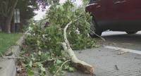
Forecasting wind direction from thunderstorms is quite the challenge and you don't have to be right underneath the storm to feel the effects. If it's storming in Carson City or Fallon for example, winds can be gusting in the 30's and 40's in Reno because of the outflow. Gusts in the 50s can bring down tree branches.
One last thing outflow winds can do is cool you off by about twenty degrees. Keep in mind straight line or outflow winds in excess of 60mph can be just as dangerous as a weak tornado, so it's not something to take lightly.