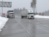
Tuesday's spring snowstorm affected many drivers traveling across the mountain passes, including the Donner Lake Interchange where CHP stopped traffic earlier in the day.
"We need the snow, but definitely we don't need no chains,” says Victor Mendoza, Center Point, Oregon.
John Whitmarsh of San Francisco adds, "Clear sailing the whole way until people starting putting chains on, so we put ours on, and then everyone's taking them off, said we didn't have to put them on for 16 more miles, so we had to put them on and take them off."
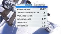
A Winter Storm Warning remains in effect until midnight Tuesday night for above 3,500 feet. The area could see 7 to 15 inches of snow with up to 2 feet of snow over higher peaks.
A Winter Weather Advisory is in effect for the greater Lake Tahoe area until 5:00 a.m. Wednesday.
The Tahoe Basin will see 3 to 6 inches with 6 to 12 inches above 7,000 feet.
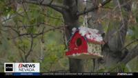
Look for scattered showers in the valley with some light snow possible in the foothills. It's also going to be cold with high temperatures only reaching the mid-40s in Reno & Carson City. Highs around Lake Tahoe are expected to peak in the upper 30s.
Showers could linger through Wednesday morning with warmer and drier weather expected by the end of the week.
You can stay up to date on weather in our area with our KTVN Storm Watch weather app.
The app gives you forecast information, like radar, storm tracking and more for any location in the country, all in the palm of your hand.
You can download it for free for your iPhone, iPad, or Android smartphone. Just search KTVN in the iTunes or Google Play Store.