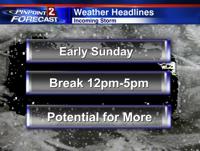
Roads will likely be covered in snow Sunday morning, not just in the Sierra but also down to the valley floor. This is why we have a Winter Weather Advisory in place for both Lake Tahoe and the Reno/Sparks area. The western slope of the Sierra has been upgraded to a Winter Storm Warning, and will last till Sunday morning. It’s a fast moving system with time for roads to improve during the day. Another system will move through Sunday night into Monday, impacting the morning commute. Both of these storms are similar in that they are both pretty quick, will bring valley snow, and have an interesting track to them. Best time to travel over the hill on Sunday would be from 12pm to 4pm with conditions improving as the day goes on. Second storm approaches the Sierra late Sunday night with another round of heavy snow likely. Timing is the same for Reno with conditions improving in the late morning as well.

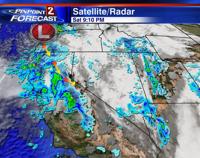
Here's what one model shows for Saturday night.
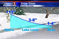
Snow totals are more complicated to figure out. The line between Reno getting several inches of snow and less than inch is very close. With the low moving out of Oregon, the potential is there for Reno to at least get some snow, but with a bit of a westerly component as well, the mountains have a decent chance too. A west northwest movement versus due north would equate to two very different outcomes. If the models are off and the low moves slightly east, snow amounts will favor the valley instead.

To be honest, the models have not been handling the current conditions very well, and have flip flopped a lot lately, so while they are spitting out less than inch for the valley, I tend to disagree. I’m going with one to four inches for Reno with over a foot in the Sierra above 7000 feet. Keep in mind even with an inch of snow, roads will still be slick in spots. It may take an hour for the roads to ice up, because we’ve been so warm lately, but it eventually will get that way.

The Sunday night Monday morning storm looks very similar and is just as much of a head scratcher in terms of how much. The direction of the low will be coming out of Oregon, so snow is definitely a possibility in Reno. Temperatures will also be colder this time around. However, this will be a very fast moving system, so conditions should quickly improve as the day goes on.
It is going to be a cold week. Highs will be in the upper 30’s on Sunday and struggle to get out of the low 40’s in Reno all week long. This is good news for our snow pack though. Make sure to stay tuned to KTVN on air and online, and we’ll make sure to keep you up to date.
