
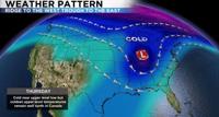
While November has been a relatively mild month for us so far, portions of the east are getting slammed with snow and frigid temperatures. While there is a ridge over us there is a trough to the east, which brings us lots of sunshine and cold wintry weather to the east. We’re hurting for some moisture around here but good news the models are hinting at a change in pattern with storms starting to move in here next week. Thankfully, I don’t think holiday travel will be impacted that much with the first couple waves looking pretty weak. The last time we got any rain at the Reno Airport was on October 6th with almost a tenth of an inch reported.


The jet stream is what drives our weather and is found in the upper levels of the atmosphere. You can think of the jet stream as a jump rope that has ridges and troughs. The jet stream also separates warm air to the south from cold air to the north. A dip in the jet stream is associated with cold air and a ridge in the jet stream is usually associated with warm temperatures. I like to think of a trough as a bowl of ice cream, because it’s cold.

The current set up has a huge ridge over the west coast and a trough to the east. As a result it’s been relatively mild around here and cold and wintry to the east. Arkansas has received snow before we have.

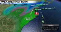
The storm started in the southeast and is climbing up the east coast bringing lots of snow, ice, and wind to that part of the country. The low is moving into Pennsylvania Friday and is expected to dump a decent amount of snow there. Portions of Virginia got a ton of ice over the past twenty four hours.
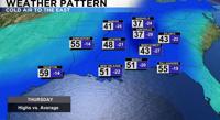
Closer to home and on the opposite side of the jet stream a ridge is in place with inversions, some high level clouds, and mild afternoon temperatures. The air is very stagnant with not a lot of wind and not a lot of moisture. While the air quality will have to be monitored, the flow has been light enough to keep the smoke in California out of here. Thankfully wind speeds have relaxed in California for now, but they could pick up again this weekend.


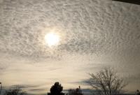
So we don’t have any moisture at the surface but we do have enough moisture aloft for some cool clouds. These are called cirrocumulus clouds and are found in the upper levels of the atmosphere and looks like rows of cotton balls. Cirro refers to the level of the atmosphere (high up) and cumulus is the shape (cotton ball ).

Going forward temperatures will be in the low 60’s through this week and into the 50’s next week. A late week storm is possible next Friday but it does not look to be all that impressive. Have a great weekend.
