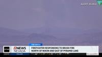
Fire danger will be critical on Friday and Saturday for most of Northern Nevada due to strong winds and dry air. Last week’s fire threat came primarily from dry lightning, and thunderstorm induced winds, but the threat this week is from sustained winds and dry air. Humans are the number one cause of fires.
An isolated thunderstorm is possible as the front moves through on Friday, but chances are very low. If one does develop, it will probably happen in Eastern Nevada.


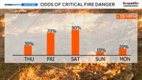
Fire danger will be high Thursday afternoon and evening, but critical Friday and Saturday.
The fire risk is high Thursday afternoon, with patches of critical fire danger. By Friday the fire threat is widespread and critical, as well as on Saturday. Thankfully, the fire threat goes down to medium on Sunday, but it’s not zero due to our fuels drying out.
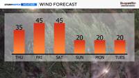
Wind speeds will range from gusting in the 30’s on Thursday, 40’s on Friday and Saturday, and up to 20 mph on Sunday. Wind speeds will be slightly stronger on Saturday than Friday. Wind speeds will be their strongest in the afternoon and evening hours, and breezy by 11am.
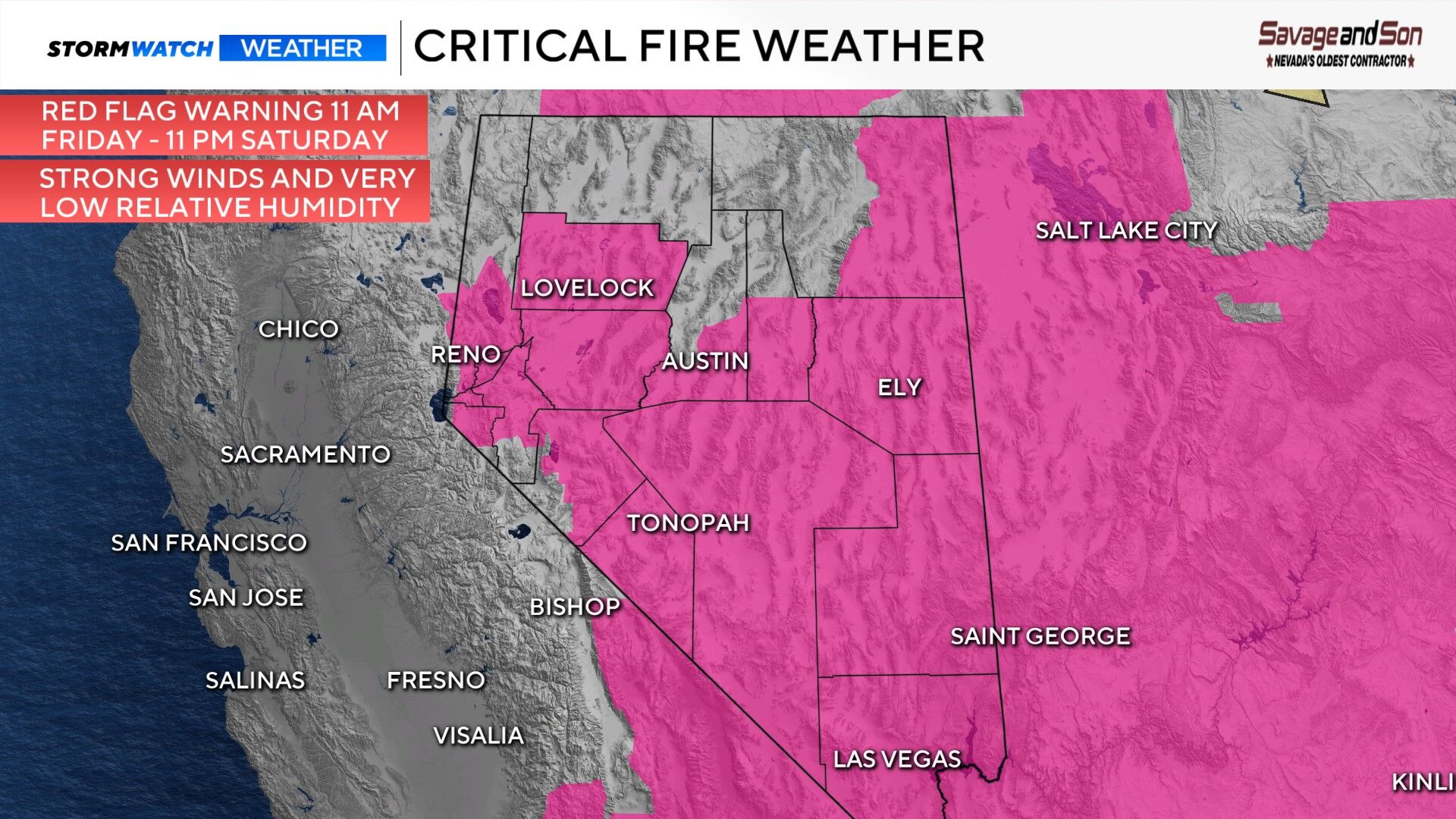
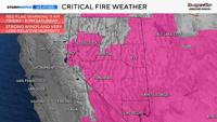
The Red Flag Warning goes from 11 am Friday through 11 pm Saturday for the Truckee Meadows, but times vary in central and eastern Nevada. Overall, both Friday and Saturday will be windy and dry, so stay fire aware. A Red Flag Warning is up for eastern Nevada on Friday, with most eastern counties under a Fire Weather Watch on Saturday.
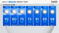
Your entire weekend is not ruined, Sunday will be a nice fall-like day with highs in the 70’s and sunny skies. Bundle up Sunday morning, as temperatures will be in the 30’s and 40’s. The Reno area will stay well above freezing, but frost is possible in the Carson Valley as well as rural areas outlying the Sierra. Places like Cold Springs will be in the upper 30’s.

The low moving in is impressive for the end of June. As the low moves in the pressure gradient will tighten and winds will pick up. There will be pockets of critical fire danger on Thursday, becoming widespread on Friday and Saturday.
As the low moves east on Sunday the pressure gradient will ease and winds will be lighter as a result. Wind is driven by pressure and temperature differences. Strong winds can make a fire grow very quickly. They can also ignite a fire where lightning struck the week before.

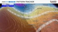
The white lines are isobars or lines of equal pressure. The more compacted they are, the tighter the pressure gradient will be, leading to stronger wind speeds.
The low is what is moving in aloft, but at the surface more than one cold front will move through as well. A cold front is the leading edge of a cooler air mass moving in. The first cold front will move through on Friday and the second one moves in on Saturday. Winds will be strong along the front and behind it. Relative humidity values will be higher ahead of the front, but staying below 20% overall. Winds will be strong enough to offset the temporary rise in humidity values as the front gets closer.

Along with fire danger, wind speeds will be strong enough to impact boating plans and travel. If you have a flight, count on there being some turbulence. Blowing dust is also possible downwind of area sinks.
A Lake Wind Advisory is up for Pyramid, Lahontan, and Rye Patch Reservoirs Thursday from 2-11 pm. There is also a Lake Wind Advisory for more of our waterways on Friday and Saturday, including Tahoe. Wave heights could reach three feet at Tahoe and four at Pyramid.