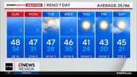
Now is the time to break out your fall clothing as cooler air moves in on Sunday.
It won’t be brutally cold, but it will be a good twenty degree drop from Friday and a ten degree drop from Saturday.
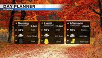
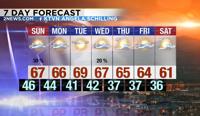
The cold front will place temperatures closer to average. Highs on Sunday will be in the mid to upper 60’s in Reno and 50’s around Lake Tahoe.
Along with the cold front comes more wind and a slight rain chance.
The snow level will be high on Sunday and amounts will be light. Roads will be fine along most mountain passes Sunday, with the exception of areas like Mt. Rose Highway above 8000’. Donner along I-80 will be fine, with more rain than anything else.
It will also be breezy on Sunday with wind gusts in the 20’s and 30’s for valley locations and near 50 miles per hour in the mountains.
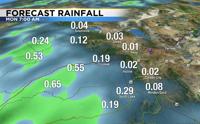
The rain will start in northeast California Sunday morning and expand south over Tahoe by the early afternoon. The valley will be heavily shadowed out, lowering rain totals.

The low will move southeast through Nevada on Monday, but the moisture will be gone by then.
Valley highs on Monday will still be in the 60’s feeling like fall. Lows will be in the 40’s. The low will also keep some cloud cover in place, before clearing out on Tuesday. Fall is here.

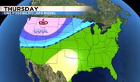
Going forward, the forecast gets trickier. One solution brings another cold low-pressure system through Nevada on Wednesday, dropping temperatures and producing more rain and wind.

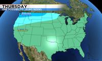
Another solution keeps the low to our northeast with flat high pressure to the south. This would keep temperatures warmer on Wednesday and Thursday.

Each solution is very different from the other. Within a model there are numerous members.
The GFS model brings colder air into Nevada, but many of its ensemble members are showing different degrees of how cold we could get.
This only adds to the variance and uncertainty. The image below shows the different paths the GFS model is predicting. A more southerly track would bring in cooler air, while a more northerly track would keep Nevada warmer.

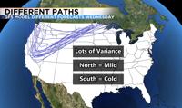
For example, if you have a deck of cards, the face card would be the GFS model showing cooler and wetter weather, and all of the non-face cards would be the other members, some showing a cooler solution and others a warmer solution.
There is a 60 percent chance of temperatures being seasonable on Wednesday and Thursday and a forty percent chance that the cooler solution will pan out.
As the low gets closer the models will have a better idea of what's going to happen.
By Monday, it will be easier to see which model is handling the weather pattern the best by looking at satellites and real time analysis.
Right now, our possible mid-week system is still a baby and way to our west.

What does this mean for you?
It will be chilly on Sunday with a slight chance for rain, and Wednesday could be unsettled too.
Be prepared for cooler air to move in mid-week, but keep the sunglasses handy too.
Make sure to be mindful of fire danger when camping this week, especially on Sunday and Wednesday because of gusty winds.
The forecast calls for temperatures in the 60’s all of the upcoming week, but make sure to stay tuned to 2News for more weather updates.