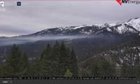
From Alert Wildfire Cameras, at Diamond Peak Wednesday morning.
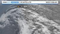
While it is cloudy Wednesday morning, the clouds are only a tease. It looks worse than it actually is. There is a good amount of moisture in the upper levels, but we are missing the energy or lift to really get any showers going. You can see the clouds on our infrared satellite image.

A ridge kept us very dry for the past couple of weeks or so, but it is finally starting to weaken. An area of low pressure is sitting offshore from the California coastline, but it is too far away to give the mountains any snow. As the low drifts south and east, it will be too far away to give us any showers on the backside of the low too.

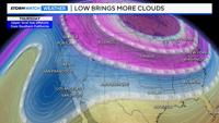
The clouds are coming up from the south southwest, in advance of the low. It will be cloudy through Friday morning, with decreasing clouds Friday afternoon behind a front. The front will slip in here from the northeast, dropping temperatures into the 40’s by the weekend. Reno is usually in the upper 40’s during the middle/end of January. Lately we’ve been running 5-10 degrees above average.

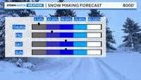
While no natural snow is in the forecast the next several days, at least it will be cold enough for our resorts to make snow this weekend. Inversions, and warm overnight lows creates a challenge for our ski resorts to make snow. Lately, it’s been warmer in the high Sierra than the valley. The inversion will break by Thursday, improving our air quality as well.