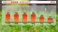
Fire danger is going to be elevated on Sunday and Monday, but at least winds will be lighter at night. Wind gusts will be near five miles per hour Saturday night, but gusting near 30mph by Sunday and Monday afternoon. Relative humidity values will stay very low as well. The National Weather Service in Reno expired the Red Flag Warning Saturday night 8pm, but they may issue another one on Sunday.

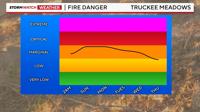
An area of low pressure is lifting northward, leaving us with dry southwesterly flow in the Truckee Meadows. The change in pressure also leads to stronger wind speeds. Relative humidity values will stay low till mid week. Highs on Sunday will be in the lower 90’s, but at least it will cool down at night.

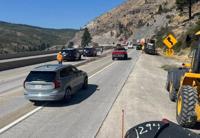
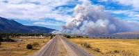
The Davis Fire started in the Davis Creek Campground Saturday afternoon and jumped 395 thanks to strong southwesterly winds. The Truckee Meadows Fire Department says they were able to attack the fire from the air as well. Reno's air quality will likely worsen Saturday night as winds relax. As of 10:15pm, most of the smoke and haze is lofted well into the atmosphere, but it will probably sink into the valley as the night goes on. With southwesterly flow forecasted for much of the work week, it will stay hazy from time to time in the Reno area from the Davis Fire. You could even see the smoke plume on our radar earlier Saturday evening.