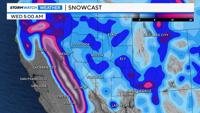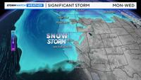
Our snowpack will get a good boost this coming week, but roads will be a mess as a result. Not only is snow likely in the Sierra from Sunday evening through Wednesday evening, but lower elevations will see some snow as well. The heaviest snow will fall late Monday into Tuesday, but chain controls will start as early as Sunday evening and will likely remain through Wednesday. There will be some breaks, but they will be short lived and brief. A Winter Storm Watch is up for the Tahoe Basin and goes from Sunday evening through Wednesday evening.
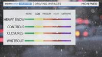
Key things to know:
1. Heavy snow is likely in the Sierra Monday through Wednesday, starts to snow late Sunday
2. Chain controls are likely with rough travel
3. Delays are likely, closures are possible
4. Visibility will be poor, whiteout conditions are possible
5. There will be some valley snow and a slick commute, especially Tuesday morning
Road closures and whiteout conditions can not be ruled out either. There is a high risk of both, especially late Monday into Tuesday in the Sierra.


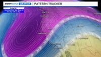
This is a classic winter storm setup for our area. We have a large upper level low dropping down from the Gulf of Alaska, and will hang around for a long time. Since it is coming from the ocean, it will have plenty of moisture to work with.

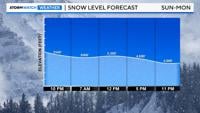
The storm will also have cold air, which will eventually drop snow levels to the valley floor, especially at night.

Areas in advance of the low will get the most uplift, and therefore snow. There will be some shadowing, but with a westerly flow, we will see some bleed over in the valley as well. If it rains hard enough in the valley it can turn to snow as well. Keep in mind, the elevation and road conditions can vary greatly in the Reno-Sparks-Carson City area, with downtown not seeing as much as say Virginia City, the North Valleys, or Galena.
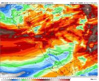
The cold air is showing up as speckled sky on recent satellite images, so it’s there. As the low travels southeast and bumps up against the Sierra, snow will be able to fly. The current low on satellite is looking more neutrally tilted than the models are showing, which makes me think the low will be stronger and have an easier time spilling over.

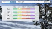
The initial low moves in late Sunday with a second low slipping south inside the main low late Monday into Tuesday. This will give the Sierra the highest snowfall rates, out of the next several days. This will also lead to a southwesterly flow, allowing the snow to spillover over to the valley. The low moves southeast on Wednesday, allowing for more snow showers to develop.
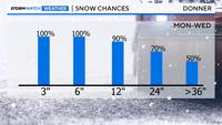
Earlier the models were showing another low slipping down inside the main low on Wednesday, but they have since changed their minds. Feet of snow will fall in the mountains by Wednesday. The Tahoe Basin at lake level could easily see over a foot of snow as well.
Winds will also be strong, especially in the Sierra. Wind gusts at the crest could very easily reach 100mph. It will be windy in the valley as well, with wind gusts near 45 mph. The wind could eat the valley’s snow chances, so that will be something to watch, but I do think we’ll get some snow. Wind speeds will reach their peak on Tuesday.
Stay tuned for more specific snow totals.