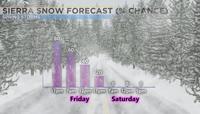
A Winter Storm Warning is up for the Sierra and goes through 11 a.m. on Friday morning.
This is the strongest storm we’ve seen yet this year. We had a significant atmospheric river that moved through the region this past October, as well as a pretty good storm that moved through in December, but other than that it’s been pretty quiet. Nothing real impressive since January.
Roads will stay slick in the mountains through late Friday morning, with gradual clearing expected throughout the day. Sunshine makes a comeback this weekend with highs expected to reach the 60s.


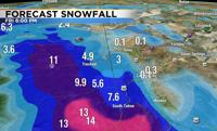
An area of low pressure is located just west of Oregon and California, with the center of it west of Portland. The eastern half of the low has already moved onshore, spreading more snow into the Sierra. The low will move east Thursday night, pushing the rain and snow farther east along with it. With a cold low overtop of a warmer surface, thunderstorms will also be possible Friday afternoon. Conditions will go from steady snow late Thursday to spotty showers Friday afternoon. Highs on Friday will be in the 50’s with decreasing clouds. If you can, wait until late Friday to get any traveling done.
The cold front moved through Reno Thursday morning, with the center of the low moving through the area early Friday. Almost two tenths of an inch of rain fell at the Reno Airport early Thursday morning.

Meteorologists look at models to see what the forecast will be. It’s like taking a multiple-choice test, and deciding which model is the right answer. The Euro, GFS, and Nam are the main models we look at, but there are also short-term models that have a higher resolution. This includes the HRRR and RAP model. Within each model, like the GFS for example are multiple versions of it. This could be like the candy Twizzlers or wrapping multiple spaghetti noodles together. Sometimes all of the different versions are on the same page, and sometimes there is a lot of uncertainty. The models are coming together, showing a warming trend through the first half of next week with high temperatures reaching 70 degrees by Monday.
After Tuesday, forecast confidence goes down. According to the Climate Prediction Center, May has a slight chance of being warmer and drier than normal.