Roads could be slick next week as a storm moves into the region along with cooler air.
This will not be a huge storm, but there will be some impacts along our mountain passes.
Next week will bring more wind than anything else to the valley, but snow is possible in the Sierra as well.
The first wave moves in around Tuesday and the second one arrives on Thursday. A higher sun angle this time of year will limit accumulations, but if it snows hard enough it could still pile up.

Confidence grows as the storm gest closer and especially if there is consistency between model runs.
Unfortunately, there is not a lot of consistency between runs, in fact the latest model runs are delaying both storms and bringing the second one in further north. Therefore, lowering snow amounts.
After a long stretch of record breaking warmth, snow is possible in the Sierra next week. It’s too early to tell how much snow will fall, but the weather pattern is trending cooler and more active.
Not only are the deterministic models showing less snow, but ensembles are also showing lower amounts and landing somewhere between hardly anything to a moderate amount for early April. Only a small fraction of the GFS’s ensembles are showing high amounts of snow next week, topping a foot.

More snow will fall on the western side of Tahoe, but the snow level will fall below 7,000’. This means that Truckee and the western shores of Tahoe will see some snow next week. Mt. Rose Highway and Spooner will get less snow than the western Sierra due to shadowing.
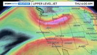
The track of the low will determine how much snow falls in the Sierra next week. Moisture will be available, and it will be cold enough for snow in the Sierra, but if the low is too far north, then we will be missing a lot of the forcing to get snow.
Precipitation amounts will be light with the first round on Tuesday. The first low will be coming out of the southwest, while the second one will slip in from the Gulf of Alaska.
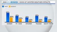
The odds of experiencing minor travel impacts in the Sierra are over 50% on Thursday, but the odds of having moderate impacts are less than 40%. More snow will fall on the western side of the Sierra, with much less snow falling along Mt. Rose Highway than Donner because of shadowing.

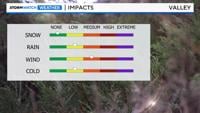
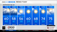
Rain amounts will be very light in the valley next week, but it will be windy. Sunday will be windy as well, with gusts in the 30’s.
By Wednesday, wind gusts will reach 40mph in the valley and at least 45mph in wind prone areas.
Wind makes it hard for rain to spill over. It will be cold enough for a jacket next week, especially with the wind.
Highs will be in the 60’s, but the wind will make it feel closer to 50 degrees. It will look and feel like winter in the Sierra next week as the snow level drops below 7,000’.