It’s been over a month since it snowed at the Reno Airport, but we have another chance this weekend as an inside slider sneaks into the area. This won’t be a huge storm, but roads will be slick in the lower elevations too. The track of this system is somewhat unique in that it will bypass much of northern California and favor Nevada as well as the southern Sierra. This is not a classic inside slider, but very similar.

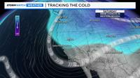
The low will develop to our north and move south over the next couple of days, bringing some snow with it.
Since it will be traveling over land, moisture won’t be abundant. The low will travel south over California, getting cut off by the jet stream late Saturday. As the low moves south, some additional snow showers will develop on the backside of the low, forming what’s called a deformation zone.
This will be a hard forecast to predict, as inside sliders and cut-off lows are hard to track.
The beginning of this system is the inside slider, and the latter is the cutoff low. The initial band is looking to set up almost right in half of Nevada, in a diagonal. The Euro is slightly further north than the GFS.
Where the deformation zone sets up is where the highest snow totals will be. As of right now, it looks to be somewhere between Highway 50 and I-80.
The Friday evening commute will be fine, with the snow starting around midnight.

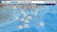
This means South Tahoe and Mono County will get at least double the amount of areas to the north. Places like Susanville probably won’t see anything. Mono County will get more snow than South Tahoe. As of now, snow totals are trending less than six inches, but there will still be impacts.

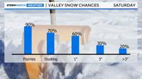
Reno could see up to a couple of inches, with less than a 30% chance of more than that. High temperatures will struggle to get above the mid-30s on Saturday, so it will stay slick for much of the day, possibly into Sunday morning. Carson City will see more snow than Reno.