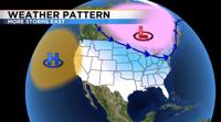
Winter Storm Warnings are posted from Oklahoma all the way up through Maine Thursday night. Meanwhile, high pressure is still in place over the Pacific Ocean blocking any moisture from getting into Northern Nevada. The jet stream works like a jump rope allowing for ridges and troughs to form and alternate between the two. This can also look like waves in the ocean.
Sometimes the jet stream is more amplified than others. An amplified pattern can be very stubborn providing long periods of dry weather or cold and stormy weather. A flatter jet stream can be more flexible and fluid. High pressure can be thought of as a dome of dry air blocking any storms from getting in here. It can also cut off our moisture source, making atmospheric rivers hard to come by.
As a result, the storms have been either staying north of us over the Pacific Northwest or staying to the east of Nevada.

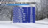
For the first time since records began in Reno, we did not see any precipitation throughout the entire month of January. So where was all the snow? An amplified jet stream pattern allows for big dips in the jet stream, it’s just falling to the east of us. Boston, Massachusetts saw the 4th snowiest January on record, and Nashville, Tennessee saw the 6th snowiest January on record. Even Columbia, South Carolina had enough snow this past month to be the 9th snowiest January on record.
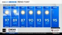
The long term models are still showing a mild and dry weather pattern for northern Nevada, but fingers crossed the pattern can change by the end of the month.