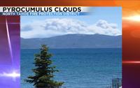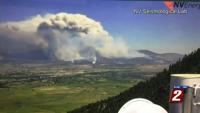

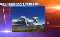

Wildfires are dangerous. The weather has a big impact on fire growth, but fires can also create their own weather. Have you ever heard of a pyrocumulus cloud? Pyro means fire and cumulus means to pile up. Cumulus clouds look like cotton balls or sheep. A cumulonimbus cloud is a thunderstorm. Nimbus stands for rain.
Pyrocumulus clouds form similarly to how a regular thunderstorm does. The main thing a thunderstorm needs is heat, and fires give off plenty of it. The heat from fires can reach anywhere from about 500 to over a 1,000 degrees Fahrenheit. The hot air rises, condenses and forms a cloud. The more heat you have, typically the taller the cloud can grow.

Just like with regular thunderstorms, pyrocumulus clouds can top 20,000 feet. They are usually darker than regular thunderstorm clouds because of all the smoke and ash. They are very similar though. Pyrocumulus clouds stay right over the fire itself.
The impacts are about the same as a regular thunderstorm. Often times pyrocumulus clouds can form dry lightning sparking new fires. They can also produce gusty outflow winds spreading the fire very quickly. The clouds Tuesday could even be seen from Lake Tahoe. If you’re lucky, pyrocumulus clouds can start to rain, putting the fire out. They can also spawn tornadoes or vorticies. This is what happened with the Carr fire a couple years ago. It wasn’t only the fire that caused a ton of damage there but also the wind from the fire tornado.