

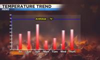
All you need is a front and plenty of moisture to change the weather. A strong area of low pressure is moving through the region, dropping temperatures and giving us a chance for rain. Which is some very good news. Our yards are very dry and the rain will help keep the air clean too. The average temperature this time is year is around 75 degrees in Reno, but it will be colder than that on Friday and early next week. The weekend will be mild as temperatures warm into the 60’s. A strong cold front moves through the region early Monday, but moisture will be harder to come by.

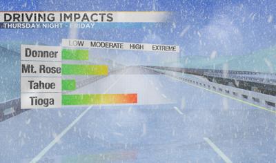
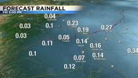
The air is cool and unsettled this afternoon allowing for showers and storms to develop. This is similar to what happens during the summer with thunderstorms, except the air is much cooler. An area of low pressure is just offshore from California. This low brings a cold pocket of air along with it, and allows the air to rise. Lightning chances goes down with time, but a few more lightning strikes are possible Thursday night, mainly east of Reno. The bulk of the rain will come Friday morning. Highest amounts will be south of Lake Tahoe, and some snow above 7000' is possible there too. Rain totals will range from a tenth of an inch to a quarter in the valley. Places like Fernley could see closer to a half inch, especially if a good thunderstorm pops up.

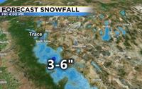
Snow totals will range from an inch at Donner, to a few inches at Mt. Rose and several inches around Tioga Pass. The jet stream is found way up in the atmosphere and separates cold air from warm air. This river of air is also where the strongest winds are found. When the jet stream is aimed right at you, the air has an easier time rising. This is why areas south of Tahoe has the best chance for precipitation Thursday night through Friday. The low will be out of here Saturday afternoon, but a few showers are still possible late Friday. Highs on Friday will range from the upper 50’s in Reno to the upper 40’s in Truckee. Watch out for an inch of snow along I80 at Donner, but accumulations will be much lower below 7500'.

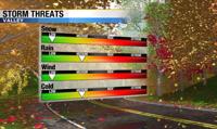
Skies will clear out just in time for the weekend, but a colder system will move through the region early Monday. This one will have less moisture to work with, but will drop temperatures well below normal. Hard freezes are likely Tuesday and Wednesday morning. We are still several days out from this one, but the models are slowly showing less precipitation than previously thought. Still something to keep an eye on though. This system could once again bring a few inches to the highest elevations, but the valley is the question mark. If we see anything at all it will be light. Highs on Monday will be in the upper 40’s with a slight breeze. Lows on Tuesday and Wednesday will near freezing even at the Reno Airport. The tilt of the low will play a big role on if we get any showers down here.

A negatively tilted low is stronger than a positive one. The latest model run is not as negatively tilted or deep, cutting off some of the moisture. After the system moves through, the rest of the work week will be quiet with a gradual warming trend. Some showers could also develop behind the front from upslope flow in the Sierra. Make sure to stay tuned to KTVN both on air and online for all weather updates.