A red flag warning is up for much of central and eastern Nevada from 2 p.m. Wednesday through 11 a.m. on Thursday.
Widely scattered thunderstorms along with dry lightning will give us the threat for new wildfire starts.
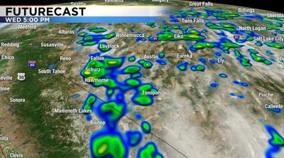
Here's a look at our Futurecast at 5 p.m. Wednesday, showing showers and thunderstorms popping up around the Virginia Range and Pine Nut Mountains, mainly east of Reno. Some of the storms will be strong around Lovelock down to Hawthorne and Tonopah with gusty winds, heavy rain and hail possible.
A stormy weather pattern lasts through Thursday, then it turns breezy and cooler for the weekend with highs in the low to mid 80s with partly sunny skies. Temperatures in the mountains will cool into the 30s for overnight lows if you have camping plans.