It’s been a cold and messy week with snow falling in the mountains and valley floor. Some spots got more than others, but it’s better than nothing.
After a long stretch of warm fall weather the storm gate opens up this weekend.
Lake effect snow is a weather phenomenon that not only develops around the Great Lakes but can also develop off of Lake Tahoe and Pyramid Lake…
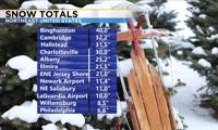
More snow fell in the Sierra Wednesday night, but the northeastern United States saw enough to break records.
Looking at the record books our area is one of the snowiest places in the country. Cold too.
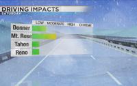
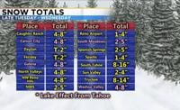
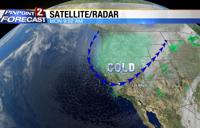
A winter storm will arrive in the valley and Sierra Tuesday afternoon, bringing snow along with it.
Our weather can change rather quickly around here, especially in the Sierra. Convective snow showers are a lot like thunderstorms during the summer where they might last for twenty minutes but can also be very powerful and produce a lot of snow.
Lake effect snow or enhancement can last either a few minutes or much longer. When it does happen it can make the roads a mess, and Thursday morning was a prime example of this.
The National Weather Service will be using a different kind of warning this year and it’s called a Snow Squall Warning.
After a messy Monday morning commute snow showers are tapering off with most of us staying dry through Tuesday. Best chance for snow today is within twenty miles south of Tahoe or Pyramid because of lake effect snow.