It’s been a cold and messy week with snow falling in the mountains and valley floor. Some spots got more than others, but it’s better than nothing.
Places like Fernley also saw lake effect snow with this storm. This wasn’t a huge storm but places like the Sierra Snow Lab got over a foot of snow.
The lab is located just off of I-80 in Soda Springs. The Reno area saw light amounts with this storm, but it was enough to make roadways slick both Wednesday and Thursday morning.
The majority of the snow in the Sierra fell on Tuesday and Tuesday night with a few spots getting a few extra inches on Wednesday.
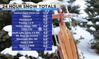
For example, Mt. Rose Ski saw four inches of snow through Wednesday morning at the summit, and only one inch through Thursday morning. The following list is through Wednesday morning and is from the National Weather Service Reno.

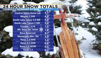
The following graphic is from Wednesday morning through Thursday morning.

As our winds switched to out of the north, lake effect snow developed off of Pyramid and Tahoe Wednesday night. Lake effect is more common in the fall, because at this time of the year, the lake is still relatively warm compared to the incoming cold air.
Most spots in and near Reno saw less than an inch of snow Wednesday night, but that is all it takes to cause some problems.
Lake Tahoe picked up several inches of snow in total with this storm. The rest of the week will be dry, with a weak system moving through Saturday night, and a stronger one rolling through early next week.
Follow me on Facebook at KTVN Angela Schilling or Twitter/Instagram at Angela Schilling for more weather updates.