Update:
A few snow showers continue in the Sierra, with chain controls up for I-80 over Donner Pass. It doesn't look like we will see much here on the valley floor. Snow is flying around Elko down toward Ely with slick conditions on I-80 in eastern Nevada. Showers taper off by late this morning with partly cloudy skies and highs in the 40s with gusty winds. www.nvroads.com
----
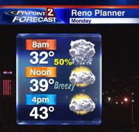
Roads will be slippery Monday morning with light snow likely falling to the valley floor by sunrise. As of 9pm, rain and snow is moving through Central California, with rain switching over to snow above 6500 feet. Some of this initial band may spill over to the valley around 11pm as well, giving Reno a light dusting of snow. We have a better chance for light snow in Reno early Monday morning. While totals will be light both times, it does not take much snow to make the roads messy. Good news though, this is a fast moving system and will be out of here by 10am at the latest. Melting begins in the late morning but temperatures will still be cold throughout the day, especially when you factor in the wind. This will be a light snow event for the Sierra as well, with just a few inches falling above 6500 feet. The drive home will be much easier than the drive there as roads clear by late morning and the left over puddles begins to evaporate. Winds will be strong behind the front with gusts topping 30mph in Reno and topping 40 miles per hour in the Sierra. They will be much lighter on Tuesday as a ridge of high pressure takes over.

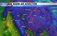
While less than an inch is expected in Reno a few inches of snow is possible in places just east of Fernley, such as Winnemucca, Battle Mountain, and Austin. Forecasting is a lot like putting a puzzle together. You need a cold air piece, a moisture piece, and a lifting piece. This time around moisture is lacking, cold air is okay, and lifting is decent. The lifting this time around is coming from something we don’t talk about a lot on television. It’s called warm air advection and can come in advance of a cold front. You can see it on the image below as the green represents warm temperatures moving into cooler light blue temperatures.

Once the cold front moves through a second dose of cold air will move in behind it and skies will gradually clear. Highs will be in the low 40’s Monday afternoon allowing for some decent melting.

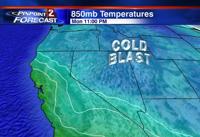
It’s going to be a cold week with highs in the 40’s and lows well below freezing. If winds go light enough, we’ll also have to watch for freezing fog Tuesday morning. Make sure to stay tuned to KTVN on air and online and we’ll make sure to keep you up to date.