
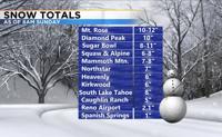
The only time it rained or snowed in Reno this past month was February 2nd, with .3” of snow and a trace of liquid precipitation. A low moved through the region Saturday night bringing a decent amount of snowfall to the Sierra and the valley. This was an inside slider type of storm meaning it came down from the north in Oregon. The track did have a little bit of a westerly component, so it was not an inside slider exactly. This was the path Reno and the Sierra needed to get snow. The eastern Sierra and western hills got the most snow this time. The valley saw anywhere between 1 to 4 inches of snowfall. Mt. Rose got about a foot of snow by Sunday morning.

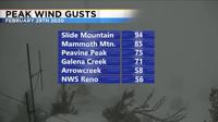
It was also windy on Saturday. This usually happens when there is a big temperature change. Highs on Friday we’re in the 60’s and we were in the 30’s Sunday. That’s impressive. Wind gusts topped 30mph in the Reno area and topped 70mph in the Sierra. Winds will be strong in the Sierra Sunday night as well.

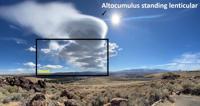
Sierra Wave Clouds can be a sign that a storm is on its way. These pictures were taken from the National Weather Service on Saturday. Virga can be a sign of strong downward vertical motion. Virga is rain that evaporates before it hits the ground.
The rest of the work week will be quiet with a gradual warming trend.