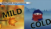
Luckily it won’t rain on the Nevada Day parade this year but the weather will take a drastic turn Sunday. Saturday will be mostly sunny with highs ranging from the mid 70’s in Reno to the mid 60’s around Tahoe. A cold front will move passed I80 Saturday night leaving cold air in its wake. The transition between warm and cold air will be a windy one.

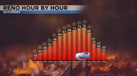
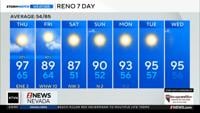
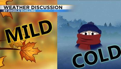
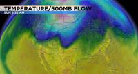
Usually cold fronts come from the west but this time around the front will come from the northeast. This is called a backdoor cold front because it comes from the east. This is an impressive front that will bring cold air down from Canada. The cold air will impact much of the United States, including as far east as the Midwest. Cyclones or areas of low pressures goes in a cycle, first bringing warm weather then wind, followed by cooler air. This weekend will be a prime example of this with warm temperatures Saturday and cold temperatures Sunday. Temperatures will drop a good twenty to thirty degrees within 24 hours.

While we don’t want it to rain on the parade we could use the rain this month. This October will go down in history as one of the driest on record. We have only a trace so far, and that has only happened four times in Reno since 1936. While there will be a few high clouds this weekend, at the surface we are still very dry. Dewpoints will only be in the teens this weekend with relative humidity values only in the teens and low 20’s as well. Best chance for rain and snow stays east of us this week.
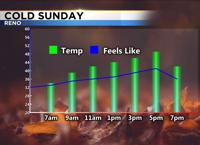
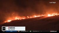
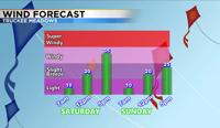
Wind gusts in Northern Nevada will reach the mid 30’s Saturday and mid 20’s Sunday. With an easterly wind late Saturday and Sunday fire conditions will be critical in California. An east wind accelerates once it goes over the hill. Combine strong winds with dry air and Red Flag Warnings are posted for much of California this weekend. Fire conditions will be elevated in the Reno area but not high enough for a warning or watch. The wind will also make it feel colder Sunday. While temperatures will be in the upper 40’s Sunday, it will feel about ten degrees colder.

The larger the trough the longer it takes to leave. Monday will be chilly as well with temperatures in the 50’s. Thanks to clear skies, light winds, and a cold air mass temperatures will fall well below freezing in the valley Monday morning. Lows will be similar Tuesday morning. The low moves out of here midweek with a gradual warming trend throughout the week. Good news for trick or treaters as highs will be in the low 60’s on Halloween. Have a great day!