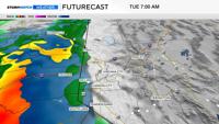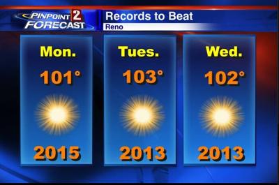
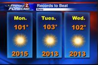
Summer is here and we’ll definitely be seeing summer like weather this week with highs forecasted to be a good ten to fifteen degrees above average. An area of high pressure anchored over Utah, will build in from the west this week and give us a second dose of dry air. Dry air tends to cool off quickly at night and heat up rather quickly during the day. If we had more moisture to work with, our low temperatures would be much warmer. However, we’ll see lots of sunshine this week, with some haze south of Reno. Winds will be a tad breezy in the afternoon each day with gusts in the 20’s and 30’s. We’ll come close to breaking a few records this week, with many of the old records set over the past few years. We'll have to make it all the way to 101° on Monday, 103° on Tuesday, and 102° on Wednesday to tie any records at the Reno Airport.
Tuesday and Wednesday will be the warmest days of the week with the center of high pressure located just southeast of Reno. Overnight lows will be in the sixties with highs in the upper 90’s and triple digits throughout this week. If you want to do something outside and beat the heat, you’ll have to do it before noon, as temperatures will already be in the 80’s by 11am and low 90’s by 1:30pm.
We have yet to make it to 100° at the Reno Airport this year, but we have plenty of opportunities this week, so make sure to stay hydrated. The warmest day on record for the month of June in Reno is 104° set back in 1940. Click on the pictures to see the records to beat as well as the outdoor forecast for Reno and Tahoe.