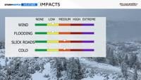
Saturday through early Sunday
There will be more tricks than treats on Halloween this year, with rain likely Saturday evening.
Rain jackets and warm layers will be needed either underneath or over top of costumes to stay warm.
Light showers or a few sprinkles are possible Saturday morning during the Nevada Day Parade, but the majority of the parade will be dry. It will be chilly, so bring jackets and blankets.


Our weather pattern is reflecting the time of year, with troughs slipping in from the north every once in a while, cooling us down.
An upper-level low is located just west of the Pacific Northwest Thursday afternoon, with a wave moving through the underside of it.
The wave will move northeast over the next 24 hours, giving areas south of Highway 50 and east of U.S. 95 a chance for light rain. The rain will be light, and light snow is possible in the higher elevations as well.

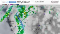
There is still some uncertainty with this weekend’s storm, due to the inconsistency between model runs.
Each run seems to change somewhat.
The cold front will move through late Saturday into Sunday, increasing rain chances.
The trough, which is located in the upper levels, will be moving east overnight as well.
The flow will be coming out of the southwest, which is favorable for spillover.
By Sunday afternoon, the trough will be just east of Reno and over the state itself. Dry air starts to filter in by late Sunday morning.

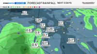
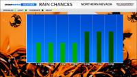
Rain totals will range from a tenth of an inch to a third. The rain will be more widespread by Saturday afternoon and evening, with light rain showers that are spotty Saturday morning.
There will be more precipitation in the Sierra. Some of it will fall as snow.

If this were the middle of December, this would not be considered a huge storm, but for the end of October, it is decent.
The upper-level low, which will open up to a trough this weekend, has cold air with it and will bring cooler air to our region this weekend.
Snow levels will drop Saturday night into Sunday morning once again.
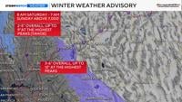
A Winter Weather Advisory goes into effect for the Tahoe Basin at 8 a.m. Saturday and goes through Sunday morning for elevations above 7,000’.
Approximately, 2-5 inches of snow will fall in the Tahoe Basin, with up to nine inches of snow falling in our highest peaks. Mono County will get a little more. The heaviest snow will fall Saturday night.

Precipitable water values give us an idea of water content, and PW values go down from west to east on Sunday, indicating a drying forecast.
There will be plenty of moisture to work with on Saturday. The upper-level low provides us with lift and energy, and the spin from lows is called vorticity.
There will be some vorticity in the Reno area Saturday evening, but not an enormous amount being advected in.
Put all of the pieces together, and Reno does have a good chance for rain by late Saturday, with snow in the Sierra. This includes Mt. Rose Highway, Donner, and Mammoth