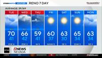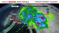
Our next storm will be part winter and part summer, with both high-elevation snow and thunderstorms. A strong area of low pressure is moving southeast on Tuesday and combining with some moisture to give Nevada and California a solid chance for rain through early Friday morning. There is a good chance for wetting rains in the Truckee Meadows, but keep in mind rain totals will vary quite a bit. The low will move inland by Thursday over Southern California, producing some showers both in advance of the low and behind it.

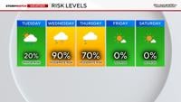
Precipitable water values will grow over the next 48 hours, with a few spotty showers possible Tuesday afternoon before the low gets closer and the moisture really gets going. The rain on Tuesday will be light to moderate, with totals ranging from 0.10–0.20”. The rain will lower the fire threat, but the trick on Tuesday will be keeping the lightning lined up perfectly with the rain. There will be plenty of rain to combat any lightning on Wednesday and Thursday.


The low will provide us with cool, unsettled air over top of warmer surface temperatures. This is a recipe for instability, which means our weather pattern will be convective, with thunderstorms. Normally, a south wind would increase shadowing in advance of a low for the valley, but since it will be convective, rain chances are fair game.


Rain totals will range from a third of an inch to three-fourths of an inch for most of Northern Nevada; however, isolated areas could get over an inch. Rain totals will be higher east of Reno and farther south. There will be a wide variety of rain totals due to the nature of thunderstorms.

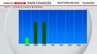
The rain will come and go, but it will be the heaviest Wednesday afternoon and evening, then again Thursday afternoon and evening. There will be some lingering showers and storms overnight as well. The rain will start to develop by noon on Wednesday, with slightly less coverage Thursday morning. While there is a 90% chance for rain late Wednesday, there is a 40% chance of thunder and lightning. Hail can’t be ruled out either.

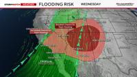
Flash flooding can’t be ruled out on Wednesday and Thursday, mainly over burn scars and in poor drainage areas. This includes the Bull, Hawk, and Bug fires near Reno. If we do see some flash flooding, it won’t be widespread, but areas that typically experience it probably will during the evening commute on Wednesday. If you see any standing water, do not drive through it. There is a better chance for flash flooding in Southern Nevada and California, as well as around the Four Corners.

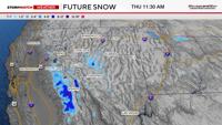
Colder air is another part of this system. It won’t be frigid in the valley, but lows will be in the thirties by Friday morning. The snow level will be around 8,000’, with snow possible on Wednesday and Thursday. Mt. Rose Highway, Ebbetts Pass, Tioga, Sonora, and Carson Pass could be slick, with a few inches of snow accumulating. Mammoth Mountain could see several inches. Donner could see a little bit of snow mix in, but impacts are highly unlikely. Impacts are more likely on the other passes listed above.
Models are in pretty good agreement with the timing of the storm and rain totals. At first, confidence was pretty low as of last Friday, but the models have come into agreement since Monday. The forecast makes sense as well. Southerly flow with some instability leads to higher rain totals when there is enough moisture. The models are showing the low a little bit more tilted than it actually is, but with southerly flow, the forecast remains unchanged.