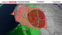
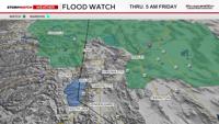
There will be more puddles during the drive home as the low slowly moves to the northeast overnight. Precipitable water values are high in Northeast California and Northern Washoe County Thursday afternoon, and there is a Flood Watch posted as a result.
The watch goes through 5 am Friday morning, and is for the possibility of flooded creeks and streams over rural roads, as well as debris flows from burn scars clogging up ditches and culverts. Make sure to turn around and not drive through flooded roads. The water is oftentimes deeper and higher than it appears.

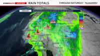
Rain totals will vary over the next 24 hours, but most spots will get between a .10-.50 additional inches of rain by early Friday morning. Localized areas that get underneath a strong thunderstorm could get an inch or more. Small hail and graupel can’t be ruled out either. The flood risk is not zero in the Truckee Meadows, but is not high either. Mainly concerned about poor drainage areas that are prone to flooding as well as burn scars.

The air is more unstable with higher CAPE (convective available potential energy, food for the storms) values along and east of US-95, giving them a better chance at seeing gusty winds and hail. Overall, flash flooding is the main concern. The Weather Prediction Center gives much of Northern Nevada a marginal risk or 5% chance of exceeding flood guidance within 25 miles. Northeast California has a slight risk or 15% chance of exceeding flood guidance.

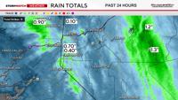
Rain totals are varying quite a bit with just under two tenths being reported at the Reno Airport so far. Higher amounts are being reported in Carson City and Douglas County. Gardnerville got .67” as of 11:46 AM on Thursday. The base of Diamond Peak Ski is reporting just over an inch of precipitation as well. The summit of Mammoth Mountain Ski is reporting at least five inches of snow just before noon.