This will be the general fire forecast each day this week with gusty winds each afternoon through 9 pm. Relative humidity values will come and go. Make sure to stay fire aware.
No Red Flag Warnings are up for the Truckee Meadows, however, fire danger will still reach high levels at times this week. Mainly in the late afternoon through early nighttime hours. This is primarily due to the Washoe Zephyr, which typically produces wind gusts around 25 to 30 mph each afternoon in evening in the Reno area during the summer season.
Red Flag Warnings are issued when relative humidity values are low and wind gusts are at least 35 mph for a longer duration. Fires can spread with wind gusts in the mid 20’s, but if the weather service issued Red Flag Warnings for that, then they would have to issue them all the time, and they wouldn’t be taken seriously.
The wind flow will come out of the southwest each afternoon, pushing any smoke left from the Hawk Fire to the northeast. Wind directions and speeds can vary up at Peavine and are typically stronger than out at the airport.

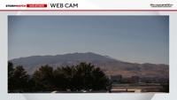
Not seeing any pryrocumulus clouds, but there are some flare ups.
Pyrocumulus clouds can’t be ruled out either, which can produce their own weather, gusty outflow winds that spread in a variety of directions. They can exceed 40 mph as well. Pyrocumulus clouds look like thunderstorms clouds and allows the smoke plumes to grow vertically. They are produced from the heat of the fire and surrounding instability and moisture.
The Washoe Zephyr is a little bit stronger than it normally is, thanks to a trough to our northwest and a ridge to our east. This creates a pathway of southwesterly winds and a somewhat tight pressure gradient of Northern Nevada. Wind gusts will be in the teens for much of the day but reach 20 mph by 3 pm.

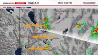
Storms are developing east of Reno Monday afternoon, and could produce gusty outflow winds that could impact the Hawk Fire.
Thankfully, there is some moisture, but it’s mainly in the mid levels. Where we really want it is at the surface. Rain would be even better, but the best chance for rain is along and east of US-95. Storms that develop to the east of Reno can also produce some gusty outflow winds, that spread out in a variety of directions. Some of the models are hinting at a slight chance for rain on Friday, but chances are low. However, relative humidity values will be higher Monday night, which will help fire fighting efforts.