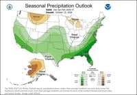
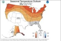
According to the Climate Prediction Center the winter forecast including the months of December, January, and February, is leaning wetter and warmer than average in the Truckee Meadows and around Lake Tahoe. There is a stronger possibility of having a wetter than average meteorological winter in Southern California and Nevada.

This is due to a strong El Niño in the Pacific. An El Niño pattern brings more moisture to the Southwest while a La Niña pattern favors the Pacific Northwest. This El Niño is being called a super El Niño, as it will be quite strong. Watch the video below to see some of the myths that come up with El Niño in our area.
You can also follow us on YouTube for more videos like this one.
Both Lake Tahoe and Reno are caught in the middle, with the jet stream either staying to our north or south, making the winter forecast more challenging. The jet stream is fluid and will move up and down during the winter season, so while the jet stream will favor areas to the south, it doesn’t mean it will never wobble up to the north at times either.
We have seen some big snow seasons during La Niña, El Niño, and neutral years in the Sierra. The reverse is true as well. Each year is different and there are other teleconnections meteorologists use to predict the winter forecast. While El Niño is a common forecasting tool to predict how much rain or snow we’ll get in the United States, it is typically not that helpful for our specific area.
While flooding can’t be ruled out this winter season, the same can be said other years too. There are a lot of factors that goes into river flooding. The amount of snow on the ground, the strength of the atmospheric river, the amount of rain, and the timing of everything all plays a role in whether we flood or not. The big Reno flood in 1997 took place before El Niño really took shape later that year.