Barrett Vinson

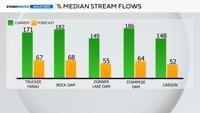
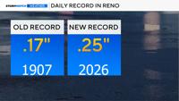
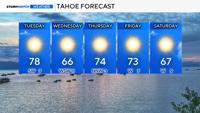
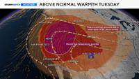
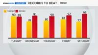
The heat wave continues on Monday with forecast highs on track to break records. High pressure is in place over the four corners leaving warm and dry conditions for the early part of the work week. Reno is on track to hit 91 degrees Monday afternoon which is one degree above the record of 90… Read moreYour Latest Forecast

  • Updated

Cooler air moves in on Wednesday, but still hot on Tuesday.

Sparks, NV

Right Now
56°
Sunny
  • Humidity: 47%
  • Feels Like: 56°
  • Heat Index: 56°
  • Wind: 0 mph
  • Wind Chill: 56°
  • UV Index: 8 Very High
  • Sunrise: 05:47:18 AM
  • Sunset: 08:03:47 PM
  • Dew Point: 37°
  • Visibility: 10 mi

Today

Mainly sunny to start, then a few afternoon clouds. Near record high temperatures. High 89F. Winds SSW at 15 to 25 mph.

Tonight

Partly cloudy. Low 59F. WSW winds at 10 to 20 mph, decreasing to less than 5 mph.

Tomorrow

Sunny skies. High 81F. Winds W at 15 to 25 mph.

Day
Temp
Tue
59°
89°
Tue
89°/59°
Mostly sunny. Highs in the upper 80s and lows in the upper 50s.

Chance of Rain: 0%

Sunrise: 05:47:18 AM

Sunset: 08:03:47 PM

Humidity: 21%

Wind: SSW @ 19 mph

UV Index: 8 Very High

Tuesday Night

Partly cloudy. Low 59F. WSW winds at 10 to 20 mph, decreasing to less than 5 mph.

Wed
45°
81°
Wed
81°/45°
Mainly sunny. Highs in the low 80s and lows in the mid 40s.

Chance of Rain: 0%

Sunrise: 05:46:20 AM

Sunset: 08:04:44 PM

Humidity: 14%

Wind: W @ 17 mph

UV Index: 8 Very High

Wednesday Night

Clear skies. Low around 45F. NW winds at 10 to 20 mph, decreasing to less than 5 mph.

Thu
49°
84°
Thu
84°/49°
Mainly sunny. Highs in the mid 80s and lows in the upper 40s.

Chance of Rain: 0%

Sunrise: 05:45:23 AM

Sunset: 08:05:41 PM

Humidity: 19%

Wind: N @ 13 mph

UV Index: 8 Very High

Thursday Night

Clear skies. Low 49F. WNW winds at 10 to 20 mph, decreasing to less than 5 mph.

Fri
46°
82°
Fri
82°/46°
Sunshine. Highs in the low 80s and lows in the mid 40s.

Chance of Rain: 0%

Sunrise: 05:44:27 AM

Sunset: 08:06:38 PM

Humidity: 18%

Wind: WNW @ 16 mph

UV Index: 8 Very High

Friday Night

Mostly clear. Low 46F. WNW winds at 10 to 20 mph, decreasing to 5 to 10 mph.

Sat
42°
74°
Sat
74°/42°
Times of sun and clouds. Highs in the mid 70s and lows in the low 40s.

Chance of Rain: 8%

Sunrise: 05:43:34 AM

Sunset: 08:07:33 PM

Humidity: 20%

Wind: NW @ 14 mph

UV Index: 8 Very High

Saturday Night

Some clouds early will give way to generally clear conditions overnight. Low 42F. Winds NNW at 10 to 20 mph.

Sun
42°
72°
Sun
72°/42°
Sunny. Highs in the low 70s and lows in the low 40s.

Chance of Rain: 2%

Sunrise: 05:42:42 AM

Sunset: 08:08:29 PM

Humidity: 21%

Wind: NNE @ 12 mph

UV Index: 9 Very High

Sunday Night

A mostly clear sky. Low 42F. Winds NNE at 10 to 15 mph.

Mon
50°
78°
Mon
78°/50°
Abundant sunshine. Highs in the upper 70s and lows in the low 50s.

Chance of Rain: 0%

Sunrise: 05:41:51 AM

Sunset: 08:09:24 PM

Humidity: 15%

Wind: ENE @ 10 mph

UV Index: 9 Very High

Monday Night

Clear skies. Low near 50F. Winds WNW at 5 to 10 mph.

Tue
53°
86°
Tue
86°/53°
Sunshine. Highs in the mid 80s and lows in the low 50s.

Chance of Rain: 0%

Sunrise: 05:41:02 AM

Sunset: 08:10:18 PM

Humidity: 15%

Wind: WSW @ 11 mph

UV Index: 9 Very High

Tuesday Night

Clear. Low 53F. Winds WNW at 10 to 15 mph.

Wed
54°
87°
Wed
87°/54°
Abundant sunshine. Highs in the upper 80s and lows in the mid 50s.

Chance of Rain: 1%

Sunrise: 05:40:15 AM

Sunset: 08:11:11 PM

Humidity: 17%

Wind: WNW @ 13 mph

UV Index: 9 Very High

Wednesday Night

Clear. Low 54F. Winds WNW at 10 to 15 mph.

Thu
52°
85°
Thu
85°/52°
Plenty of sun. Highs in the mid 80s and lows in the low 50s.

Chance of Rain: 4%

Sunrise: 05:39:30 AM

Sunset: 08:12:04 PM

Humidity: 17%

Wind: NW @ 12 mph

UV Index: 9 Very High

Thursday Night

Mostly clear skies. Low 52F. Winds WNW at 10 to 15 mph.

Today's Weather Story

Get up-to-the-minute news sent straight to your device.

Topics

Breaking News