
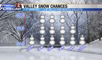
Sorry folks but more snow is in the forecast Saturday night into Sunday. The majority of the snow will come late Saturday night while you are in bed, with some scattered snow showers popping up Sunday afternoon as well. The mountains will receive the brunt of this cold storm with 1-3 feet possible above 7000’.


We’re already seeing some light rain and snow in Reno this evening, but it will switch to all snow by midnight. The atmosphere is made up of different layers, and each one plays a part in the forecast. At the surface we have a cold front moving through, and in the upper levels we have a cold area of low pressure. Both of these features will help to produce snow bands in the Reno area Saturday night. The image below is from 850mb, and shows the difference in temperature behind the front compared to out ahead of it. Red means warm and blue means cold. Any early Saturday night precipitation is the precursor to the frontal band itself.

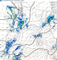
The front will begin to move through around midnight, cooling the air drastically behind it. Snow will form near the front itself too, with the snow band exiting south Reno by sunrise. A secondary band may move through late morning as well. The upper level low will move east Sunday afternoon keeping us unstable throughout the day. Unstable meaning, conditions are right for a few showers to pop up on radar. To be unstable you need warmer air below cooler air. The low aloft provides the cooler unsettled air, but chances for showers will dwindle with time. Totals will range from a few feet in the high Sierra, to around a foot at lake level, and a few inches at the Reno Airport. In the hills/north valleys, anywhere between 4-8 inches is not out of the question.

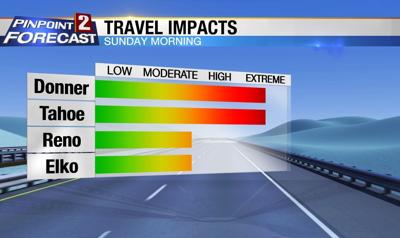
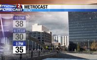
Temperatures are tricky Sunday afternoon, not going to lie. One thing is for sure it will be cold, especially when you factor in the wind. Gusts could top 30mph again Sunday afternoon, making it feel even colder, and lowering visibility. We’ll probably reach our Sunday high temperature at midnight, and then see temperatures around freezing at sunrise, followed by mid 30’s during the afternoon. Skies will be slow to clear Sunday afternoon, but we’ll see a few breaks late in the day. As a result, some melting is likely by 1pm in Reno, but how much highly depends on how much sun we receive. The afternoon will likely be better for driving, but not one hundred percent safe.

For more weather information you can always follow myself on Facebook at KTVN Angela Schilling or on Twitter at Angela Schilling. Our weekend newscasts are at 5:00, 6:30, and 11pm. Stay safe and enjoy the snow.