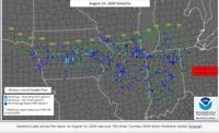
While we can see our fair share of thunderstorms in northern Nevada, they usually don’t last very long. This is unlike the strong line of thunderstorms that started in northern Nebraska and moved all the way through Indiana Monday. The line of storms crossed 750 miles in one day. That’s impressive. The complex of storms that moved through the Midwest on the 10th is a classic example of a derecho.

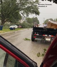
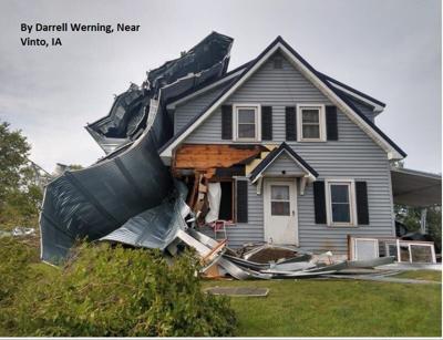
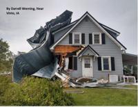
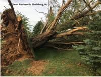
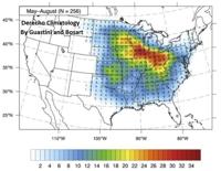
A derecho is a severe line of thunderstorms that lasts for at least 250 miles. It has to have a steady amount of wind gusts near or above 58 miles per hour for most of its journey, with several gusts of at least 75 miles per hour. Unfortunately, the derecho produced lots of damage and numerous injuries throughout its path. The photos in this blog were sent to a local National Weather Service office in eastern Iowa.

Derechos are fueled by instability and need some shear to keep them going. Instability is how likely parcels of air can rise throughout the air. Warm air rises, so if there is cooler air in the upper atmosphere and hot air at the surface, there will typically be a lot of instability. Shear is a difference in wind direction or speed with height. Shear helps tilt storms. The tilt of the storm separates the warm air from the cool air inside the storm. If the storm was not tilted, the warm air will combine with the cool air, and kill the storm. Hot air fuels storms. Since our storms lack shear, they usually don’t last very long. Therefore, derechos are not very likely to move through our area.

Derechos look like a large bow and arrow on radar. In person they can look like a tidal wave or shelf. There is usually a portion of lighter rain behind the most intense arrow or comma shaped line of thunderstorms. This portion of lighter rain can be a sign of inflow being fed into the storm and strong winds. This helps to propel the line of thunderstorms forward.

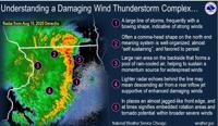
While we don’t typically see derechos in our area, we can get sustained winds over 30 miles per hour for a long period of time. This can happen from a low moving through, and can happen anytime throughout the year. We can especially see this in the wintertime when there is a storm moving through, producing lots of snow in the mountains, and staying dry in the valley. Derechos can produce a lot of damage. Not only because of the wind itself, but also from tornadoes embedded within the line of thunderstorms, as well as hail and heavy rain. According to the National Weather Service, at times the derecho produced wind speeds of 110 miles per hour in eastern Iowa, ultimately, uprooting trees, damaging outbuildings, grain bins, and houses. There were numerous injuries as well. There have been 11 confirmed tornado reports in the Chicago area so far.

We have a chance to see some thunderstorms in northern Nevada beginning Friday and going through this weekend. The storms could produce lightning, heavy rain, gusty winds, and small hail. To avoid getting stuck in a storm you’ll want to get your outdoor activities done early. They will most likely start in the afternoon.