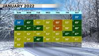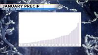
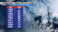
It’s been a very dry January with no precipitation falling at the Reno Airport. This has never happened in Reno before since records began in the 1930s. Tahoe City did see some light precipitation this month, but not enough to really help our cause. High pressure has continued to sit in the Pacific and block storms and moisture from getting in here. While we’ve had a very mild January the eastern part of the United States has had a very active January. The jet stream is like a jump rope with hills and valleys. The extended forecast for the beginning of February is dry in the west with precipitation likely staying below normal levels. Tahoe City has gone through the month of January without any snow numerous times, but .03” is the least amount of precipitation that’s ever fallen there since records began. Just under two tenths of precipitation has fallen so far this month in Tahoe City.

We’ve had a lot of mild days this month with highs staying in the 50’s most of the time. Reno’s monthly average is at least several degrees cooler than that. The average high in Reno is around 50 degrees by the end of January but closer to 45 degrees in the beginning. It was a cold start to the month with highs in the 30’s, but then everything changed a couple days later. January 13th was the warmest day of the month. The high that day was 64 degrees. The last week of January was seasonable in terms of temperatures with highs close to 50 degrees. A cold front will move through northern Nevada by Tuesday, dropping temperatures into the lower to mid 40’s. The odds of seeing precipitation in Reno Monday is less than 10 percent. This gives Reno a very good chance of having the driest January on record.