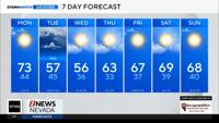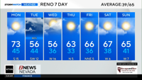


We're looking at below-average temperatures across the region on Monday, with a chance for isolated afternoon showers—mainly impacting Mono and Mineral counties.
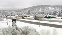
A few of those showers could even bring brief thunderstorms, with lightning, small hail, and gusty winds up to around 30 miles per hour. Snow levels will stay above 6,000 to 6,500 feet, and any accumulation should remain light.
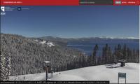
Elsewhere, including the Tahoe Basin and parts of northern Washoe County, only spotty showers are expected, along with cool conditions and a brisk north to northwest breeze.
We'll catch a bit of a break on Tuesday, with mostly clear skies and temperatures climbing back closer to seasonal averages. But that won't last long—a fast-moving system out of the Pacific Northwest arrives late Wednesday into Thursday, bringing another round of gusty winds, valley rain, and mountain snow as a cold front pushes through.
Looking ahead, we stay in an active weather pattern through the end of the week, with cooler conditions lingering before a gradual warm-up into the weekend. However, the storm door remains open, and another Pacific system could approach by late next weekend.