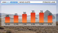
Lake Wind Advisory goes from 2pm - 11pm Wednesday. Wind gusts up to 35mph and wave heights between one to three feet.
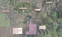
A Lake Wind Advisory is in effect for Pyramid Lake on Wednesday due to wind gusts reaching 35 miles per hour and creating wave heights of one to three feet. The advisory runs from 2 p.m. to 11 p.m. on Wednesday and includes Pyramid Lake, Lahontan, and Rye Patch.
The National Weather Service is giving the advisory a risk level of 2 out of 5, which is considered minor but should not be ignored. Waves will be large enough to topple small watercraft, such as paddleboards.

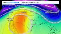
The culprit for the gusty winds is a cold front moving east late Wednesday. Highs on Wednesday will near 80 degrees, but they will only be in the mid to upper 60s on Thursday. Wind is related to pressure, which is related to temperature. The bigger the temperature change, the stronger wind speeds can be. A large temperature change is associated with a tight pressure gradient, increasing wind speeds.
The ridge is still here but is slowly moving east. Cooler air is to our northwest and will slip into Northern Nevada by Thursday. Warm air next to cooler air creates a wind channel. It is also warm enough for the Washoe Zephyr to develop Wednesday evening, but the tightened pressure gradient will make it slightly stronger than normal.

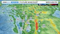
The second half of Wednesday will be windier than the first half, thanks to the Washoe Zephyr and the timing of the front. Wind gusts will reach 20 mph by lunchtime and 35 mph by 3 p.m. It will be a tad windy in the Reno area as well, but not much stronger than the last couple of days. Wind speeds will be strong enough to notice, but it won’t be a major windstorm. Even though it is not the dead of summer, it is still important to stay fire-aware. Click here to view the latest weather forecast and video update.