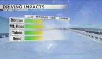
After going 46 days straight with no rain or snow in Reno, a weak system will move through the region late Monday. The front will drop temperatures from the mid 60’s all the way down to the 40’s on Tuesday. Snow amounts will be light, but enough to make roadways slick for the Tuesday morning commute. This will be a shock to the system after reaching 70 degrees in Reno on Sunday. According to the National Weather Service, this is something that has only happened five times in February, in three different years. Reno usually sees its first 70 degree day in mid March. Mid latitude cyclones usually have a warm front and a cold front. The warmest part of the storm is found before the cold front. This partly explains why it was 70 degrees Sunday and will be much colder on Tuesday.


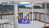
The direction of the low will be from the north, bypassing much of the sierra and giving the Truckee Meadows a good chance at snow. This is called an inside slider, because it will slide into the valley. Temperatures will be cold enough for the precipitation to eventually turn over to snow. Since this is a fast system, snow totals will be light. The precipitation will start out as rain or a rain/snow mix Monday night at 10pm, before switching all over to snow by 12am. The storm will be a fast mover and out of here by mid-morning Tuesday. Snow totals will range from a dusting to a couple inches. The foothills and lake Tahoe area has the best chance at picking up a couple inches. The central and eastern part of the state will see light snow as well. Roads will be slick Tuesday morning, but they will improve quickly and be completely dry by the early afternoon.

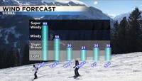
It will be windy Monday before the front arrives. Wind gusts will range from over 60mph in the high Sierra to closer to 40 mph in the valley. Wind prone areas in the valley could see wind gusts closer to 50mph on Monday. It will still be windy Tuesday morning in the Sierra, but wind speeds will relax throughout the day.