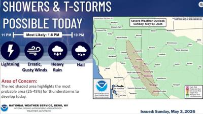

The National Weather Service in Reno has issued a Severe Thunderstorm Warning for southern Washoe County and southwestern Pershing County through 4 p.m.
At 2:51 p.m., Doppler radar was tracking a strong thunderstorm over Reno, moving northwest at 40 mph.
The Weather Service says gusty winds could knock down tree limbs and blow around unsecured objects.
Locations impacted include:
Pyramid Lake, Nixon, Sutcliffe, Virginia Peak, The Needle Rocks, and Tohakum Peak.
Thunderstorms and high winds are also impacting Plumas, Sierra, and Lassen County.
At 3:24 p.m., Doppler radar was tracking strong thunderstorms along a line extending from 6 miles north of Spanish Springs to near Cold Springs to 6 miles northwest of Dog Valley. Movement was north at 20 mph.
Wind gusts of 50 to 55 mph are possible.
Gusty winds could knock down tree limbs and blow around unsecured objects. Strong crosswinds along US-395 could bring difficult travel for high profile vehicles.
Locations impacted:
Beckwourth, Doyle, Herlong, Chilcoot, Susanville, Vinton, Cold Springs, Cold Springs Valley, Standish, Janesville, Chilcoot-Vinton, Hallelujah Junction, Frenchman Lake, Antelope Lake, Lemmon Valley-Golden Valley, Lake Davis, Spanish Springs, Loyalton, Susanville Municipal Airport, and Boulder Creek Campground.
(National Weather Service Reno assisted in this report)