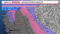

As one storm leaves another storm comes in right behind it. Winter Storm Warnings are up for the western slope of the Sierra, and a Winter Weather Advisory is posted for the Tahoe Basin through 11pm Friday night. Snow totals will range from 2-6 inches at lake level on the east shore, to 15 inches at the crest. This a fast moving storm, associated with a shortwave, which will be out of here by midnight.
Another storm moves in late Sunday. Sunday’s storm will bring a lot of wind to the valley, with more heavy snow in the Sierra through Monday. The storm gate is still open and our snow season is finishing strong.
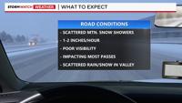
Friday’s storm is not as impressive as our most recent storm, but it is still a healthy looking system. Count on chain controls and delays throughout much of Friday, before drying out Saturday morning. There will be some spill over in the valley, with a mix of rain and snow possible. The precipitation will melt as it hits the ground, leading to wet roadways. Highs on Friday will be in the mid 40's for the Truckee Meadows. It won’t be a washout Friday, with a lot of dry time as well.

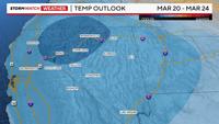
There is enough moisture to work with in the Sierra Friday morning, but it will take some time for the valley to saturate enough for the rain or snow to reach the surface. Snowfall rates could exceed an inch per in the Sierra Friday, piling up quickly. Models are showing another foot or two of snow in the high Sierra next week, with colder air moving in as well. The extended forecast is leaning colder than average.