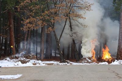

As part of Humboldt-Toiyabe National Forest’s hazardous fuels reduction efforts, the Spring Mountains National Recreation Area’s (SMNRA) fire crews will begin pile burning beginning in January, weather and fuel conditions permitting.
Prescribed fire is a proactive tool for several purposes, including reducing hazardous fuels (overgrown vegetation).
The three general types of prescribed fire are pile burning, understory/underburning, and broadcast burning. They all help decrease the threat of high-intensity, high-severity wildfires; reduce the risk of insect and disease outbreaks; recycle nutrients that increase soil productivity; and improve wildlife habitat. Another benefit resulting from prescribed fire is a reduction in wildfire danger to local communities.
The actual days of ignition for pile burning will depend on several factors, including appropriate humidity levels, wind speed and direction, temperature, and fuel moisture. Burns only occur on days when weather conditions exist for smoke dispersal. The public can get prescribed burn updates by visiting the Forest’s Facebook page here: U.S. Forest Service-Humboldt-Toiyabe National Forest | Sparks NV | Facebook
Air quality considerations are an essential part of prescribed fire, and each fire prescription is planned to disperse smoke rapidly and reduce lingering haze.
Before each prescribed fire is ignited, fire managers will get approval from the local air quality district in which the burn is to take place.
Fire crews divide extensive landscape burns into blocks of land over multiple days.
Please do not call 911 about burning in the areas listed below. Local fire departments are aware of these burning activities.
Possible burn locations include:
- Potosi Pass
- Roughly 100 acres of pile burning is planned in the Mt. Potosi area near mile marker 20 on Nevada State Route 160, one mile south of Mountain Springs, Nevada.
- Coal Springs/Lovell Summit
- Roughly 300 acres of pile burning is planned along the Forest Service Road 45536 (Lovell Summit Road) between Lovell and Trout Canyons.
- Clark Canyon
- Nearly 250 acres of pile burning is planned near Clark Canyon, approximately 15 miles northeast of Pahrump, Nevada.
- Lee Canyon Guard Station
- Roughly two acres of pile burning is planned along the north side of Nevada State Route 156 (Lee Canyon Road) near mile marker one.
- Camp Stimson
- Approximatively 20 acres of pile burning is planned near mile marker six on Nevada State Route 158 (Deer Creek Highway), one-half mile northwest of Deer Creek Picnic Area.
- Rainbow Canyon Summer Homes
Around 49 acres of pile burning is planned near mile marker two of Nevada State Route 157 (Kyle Canyon Road), one-tenth of a mile southeast of the Kyle Canyon Rainbow subdivision
For information on pile-burning activities on the Spring Mountains National Recreation Area, please contact SMNRA Fire Management Officer Ray Dombroski at raymond.dombroski@usda.gov or 702-515-5422.


