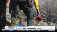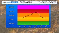
High pressure will keep temperatures above average through Saturday, before a trough moves inland by Monday. As the low gets closer, wind speeds will get stronger, and there will be a few extra clouds on Sunday. Overall, it’s a nice holiday weekend forecast, but make sure to stay fire aware. Monday won’t be a great boating day, because of choppy waters. Wind gusts could top 30mph on Monday, combining with low relative humidity values to create critical fire danger.

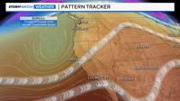
Highs on Saturday will be in the mid 90’s, before cooling a couple degrees on Sunday. Lows will be in the upper 50’s and low 60’s. The air is very dry, allowing temperatures to cool quickly after dark and heat up quickly during the day. It’s a nice forecast at Tahoe this weekend, with temperatures in the low 80’s on Friday, and 70’s over the weekend. It will be breezy though, mainly on Sunday and Monday. High pressure is in place for now, keeping the storm track all the way up into Canada. A trough is brewing in the Pacific, and as it gets closer the pressure gradient over western Nevada will get tighter. The tighter the pressure gradient, the stronger wind speeds will be.

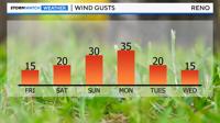
A ridge close to a low is a good recipe for strong winds, because of a tight pressure gradient. Wind gusts could reach 30mph on Sunday and top 30mph on Monday. Strong winds can carry a fire rapidly, so wind speeds are not something to take lightly in our area. There is a very slight chance of a stray shower or thunderstorm on Sunday and Monday, but most of them will be in central and eastern Nevada. Fire danger will be a bigger concern.