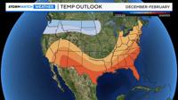
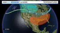
Fall weather is here and the winter outlook is posted for the country. According to NOAA there is a 60% chance of La Niña setting up this fall and lasting through the winter season. La Niña and El Niño moves the jet stream either up or down, oftentimes leaving the Truckee Meadows and Tahoe somewhere in the middle. La Niña favors the Pacific Northwest with the jet stream bumped up to the north. This leaves the southern half of the United States warm and dry.

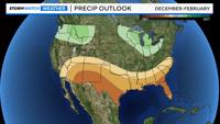
According to the Climate Prediction Center the Pacific Northwest is leaning wetter than average and colder than average. South Texas, Arizona, and New Mexico are forecasted to be warmer and drier than average. This leaves the Truckee Meadows and Sierra with an equal chance of either scenario. A weaker La Niña would allow the jet stream to wobble a little further south.

So what causes La Niña or El Niño? It all has to do with the Trade Winds and temperature changes in the Pacific Ocean. Normally, the Trade Winds are just strong enough to flow east to west, allowing for some colder water to well up off the coast of South America. El Niño occurs when the Trade Winds are weaker than normal and some of the warm water moves back towards the east. A La Niña pattern develops when the Trade Winds are stronger than normal, allowing for even colder water to develop off the South America coastline. The cold water allows the jet stream to move up to the north over Oregon and Washington, leaving warmer and drier air down to the south.

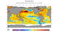
We are currently in a neutral phase, with water temperatures at or slightly below average in the Eastern Pacific. It's likely sea surface temperatures will get even colder by the end of the fall season, putting us in a La Niña setup.